
Ramat Razi'el is a climb of 7.4 kilometers (category 1). Ramat Razi'el tops out at 740 m above sea level. It is located in מועצה אזורית מטה יהודה, מחוז ירושלים, ישראל. The average gradient is 6.9% with a maximum of 15.5%. The climb has 506 meters of elevation gain.
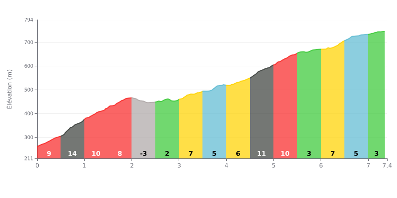
Difficulty breakdown: This climb has a demanding profile, with a very tough opening section (gradients of 9%, 15% and 10% over the first 1.5 km), followed by a relative respite between km 2.0 and 3.0. The finish stays steady, with sections at 11% and 10% after km 4.5. The average gradient of 6.9% over 7.4 km is typical for a Cat 1 climb.
Pacing advice:
1. Start easy: Don't go out too hard. Hold something back for the steep ramps between km 0.5 and 1.5.
2. Active recovery: Use the slight descent (km 2.0-2.5) and the easier gradient (km 2.5-3.0) to ease off a touch and get your breathing and rhythm back.
3. Steady through the final kilometres: Be ready for the ramp back up after km 4.5 (11%) and keep a consistent rhythm all the way to the summit.
7.4 km • 506 m D+
VAM: average climbing speed, based on elevation gain


Join thousands of cycling fans! Plan your rides, record your performance, track your progress and discover the finest climbs.
Live climb profile to pace your effort all the way to the top.

