
Har Kitron is a climb of 12.0 kilometers (category 1). Har Kitron tops out at 724 m above sea level. It is located in מועצה אזורית מטה יהודה, מחוז ירושלים, ישראל. The average gradient is 3.7% with a maximum of 12%. The climb has 446 meters of elevation gain.
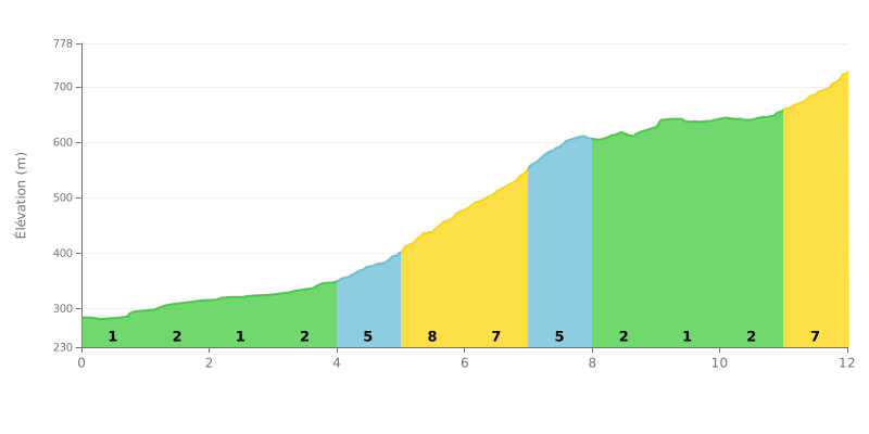
Difficulty analysis: This Category 1 climb has a tactical profile. The difficulty is concentrated in a 3 km central section (from KM 4.0 to KM 7.0) with severe gradients of 5% to 8%. The final kilometer at 7% is a significant closing test after a more rolling section.
Pacing tips:
1. Managing your pace on the central section: Don't go out too hard. Save something in the tank for the KM 5.0-7.0 wall (8%) and the final 7% ramp.
2. Make the most of the easier sections: The first few kilometers and those between KM 8.0 and 11.0 (1-2% gradients) are ideal for recovering and refueling.
3. Plan for the finish: Tackle the last kilometer with a gearing you can spin, so you can hold your rhythm on the 7% slope.
12.0 km • 446 m D+
VAM: average climbing speed, based on elevation gain


Join thousands of cycling fans! Plan your rides, record your performance, track your progress and discover the finest climbs.
Live climb profile to pace your effort all the way to the top.

