
Bar Giyora is a climb of 6.5 kilometers (category 2). Bar Giyora tops out at 730 m above sea level. It is located in מועצה אזורית מטה יהודה, מחוז ירושלים, ישראל. The average gradient is 4.5% with a maximum of 10.5%. The climb has 296 meters of elevation gain.
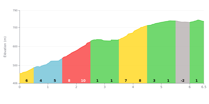
Difficulty breakdown: This 6.5 km climb has a very uneven profile. The difficulty is concentrated in three steep sections: a brutal stretch of 8% then 10% between 1.5 and 2.5 km, followed by a welcome breather, then another wall at 8% and 7% between 3.5 and 4.5 km. The descent at km 5.5 is an unexpected tactical element.
How to manage the effort:
1. Pace yourself: Don't go too hard in the first few kilometers. Save something in the tank for the two main walls (around 2 km and 4 km).
2. Make the most of the flat sections: The 1% sections (km 2.5-3.5 and 5.0-6.0) are crucial for recovering and refueling before the tougher climbing.
3. Plan for the descent: The short downhill at km 5.5 lets you ease off the pressure and get ready for the final push up to the finish.
6.5 km • 296 m D+
VAM: average climbing speed, based on elevation gain


Join thousands of cycling fans! Plan your rides, record your performance, track your progress and discover the finest climbs.
Live climb profile to pace your effort all the way to the top.

