
Beit Shemesh is a climb of 4.3 kilometers (category 3). Beit Shemesh tops out at 534 m above sea level. It is located in מועצה אזורית מטה יהודה, מחוז ירושלים, ישראל. The average gradient is 4.8% with a maximum of 11.7%. The climb has 207 meters of elevation gain.
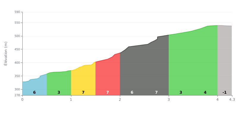
Difficulty analysis: This 3rd category climb is moderately hard. Its average gradient of 4.8% over 4.3 km is fairly standard, but the pacing is what matters: the first half (KM 0.5 to 2.5) is the tougher one, with four sections at 6-7%, while the second half (KM 3.0 to 4.0) is easier (3-4%), finishing with a short descent.
Tips for managing your effort:
1. Start easy: Resist the urge to go over the top in the first steep kilometres. Save some in the tank for the two 7% sections (KM 1.5-2.0 and 2.5-3.0).
2. Active recovery: Use the less steep parts (KM 3.0-4.0) to ease off a bit and recover before the finale.
3. Gear selection: Anticipate the frequent gradient changes so you can adjust your gear smoothly, especially before the short descent at the end.
4.3 km • 207 m D+
VAM: average climbing speed, based on elevation gain


Join thousands of cycling fans! Plan your rides, record your performance, track your progress and discover the finest climbs.
Live climb profile to pace your effort all the way to the top.

