
Valteřice is a climb of 3.1 kilometers (category 2). Valteřice tops out at 738 m above sea level. It is located in Štíty, Střední Morava, Česko. The average gradient is 8.1% with a maximum of 13.1%. The climb has 251 meters of elevation gain.
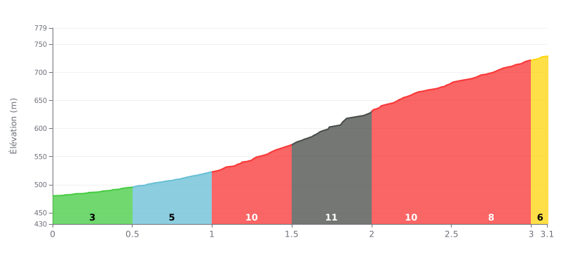
Difficulty analysis: This Category 2 climb has a demanding profile. The main challenge is the central kilometre (1.5-2.5km), where the gradient hits 12%, preceded by a section at 10%. The start is relatively manageable (3%-6%), but the effort quickly becomes very intense for the second half of the climb.
How to manage the effort:
1. Set your pace from the first kilometre: Resist the urge to go too hard on the gentle opening slopes (3%-6%). Save your legs for the critical 10-12% sections.
2. Prepare for the heart of the climb: The gradient ramps up sharply after 1km. Get your head and legs ready for the 12% attack by finding a steady, sustainable rhythm before you reach this decisive section.
3. Make the most of the easier finish: The last two segments (8% and 7%) offer some respite. Use them to recover a little and keep a solid cadence all the way to the summit.
3.1 km • 251 m D+
VAM: average climbing speed, based on elevation gain


Join thousands of cycling fans! Plan your rides, record your performance, track your progress and discover the finest climbs.
Live climb profile to pace your effort all the way to the top.


Within 20 km