
Na Hranicích is a climb of 4.4 kilometers (category 3). Na Hranicích tops out at 658 m above sea level. It is located in Štíty, Střední Morava, Česko. The average gradient is 4.9% with a maximum of 8.5%. The climb has 215 meters of elevation gain.
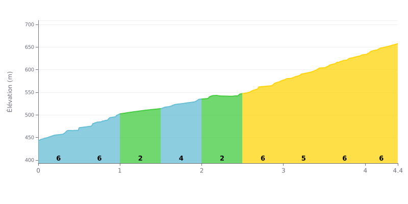
Difficulty breakdown:
This 3rd category climb is moderately hard because of its uneven profile. The 4.9% average gradient is deceptive: the road alternates gentle sections (2-3%) with harder stretches, including a final push at 7% over the last 400 metres. Kilometres 0.5-1.0, 2.5-3.0 and 3.5-4.0, all at 6%, are the key segments where the effort will be at its hardest.
How to manage the effort:
1. Pace yourself from the bottom: The first two half-kilometres at 6% can tempt you to go out too hard. Keep your effort in check to save something for later.
2. Make use of the breathers: Kilometre 1.0-1.5 (2%) and the 2.0-2.5 stretch (3%) are good chances to recover actively by easing off a little without losing speed.
3. Save something for the finish: Keep some energy in reserve for the last 400 metres at 7%, the steepest section of the climb.
4.4 km • 215 m D+
VAM: average climbing speed, based on elevation gain


Join thousands of cycling fans! Plan your rides, record your performance, track your progress and discover the finest climbs.
Live climb profile to pace your effort all the way to the top.

