
Hambalek is a climb of 5.7 kilometers (category 4). Hambalek tops out at 527 m above sea level. It is located in Olšany, Střední Morava, Česko. The average gradient is 3.1% with a maximum of 6%. The climb has 177 meters of elevation gain.
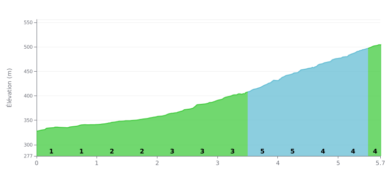
Climb analysis: This 4th category climb is a gradual, progressive one. The first half (up to KM 2.5) is very easy, with gradients of 1% to 3%. The difficulty ramps up noticeably in the second part, with gradients of 4% to 5% over the last 3 km. A total elevation gain of 177m over 5.7km makes it a manageable climb, but it demands a steady rhythm.
Tips for pacing yourself:
1. Manage your pace: Don't get fooled by the easy start. Ease into it and save your legs so you arrive fresh at the steeper ramps near the end.
2. Anticipate the gradient changes: The road kicks up to 4% at KM 2.5 and to 5% at KM 3.5. Get ready mentally and physically for these increases so you don't blow up when the gradient hits.
3. Keep a steady cadence: Once you're into the steepest section (KM 3.5-4.5 at 5%), find a gear that lets you hold a smooth, consistent cadence all the way to the top.
5.7 km • 177 m D+
VAM: average climbing speed, based on elevation gain


Join thousands of cycling fans! Plan your rides, record your performance, track your progress and discover the finest climbs.
Live climb profile to pace your effort all the way to the top.

