
Przełęcz pod Średnicą is a climb of 4.5 kilometers (category 3). The climb finishes at 594 m above sea level. It is located in Strużnica, województwo dolnośląskie, Polska. The average gradient is 3.5% with a maximum of 7.1%. The climb has 157 meters of elevation gain.
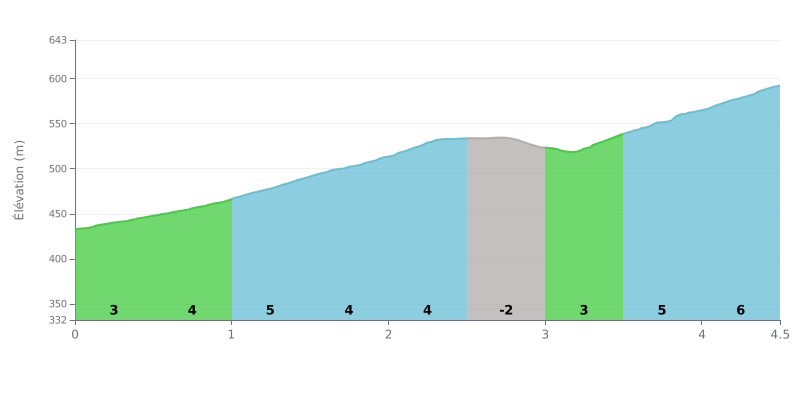
Climb breakdown: With 4.5 km for 157 m of elevation gain and an average gradient of 3.5%, this 3rd category climb is within reach of any regular rider. The difficulty lies mostly in keeping a steady effort, because no section is really steep. The 1.0-1.5 km, 3.5-4.0 km and 4.0-4.5 km stretches, all at 5%, will hurt your legs more. The 2.5-3.0 km section, slightly downhill (-2%), gives you a short breather in the middle of the effort.
Tips for pacing:
1. Ease into it: over the first 0.5 km at 3%, keep the effort moderate so you still have something in the tank for later.
2. Recover on the dip: use the 2.5-3.0 km section to spin out your legs, catch your breath and get your cadence smooth again.
3. Save something for the finish: the final 1.0 km at 5% (3.5-4.5 km) calls for an easier gear and a steady rhythm all the way to the summit.
The pass sits between Gruszków and Kowary, in the Rudawy Janowickie. Reports mostly cover hiking and very little cycling, but those who have ridden up say the climb is hard from both sides. The road linking Kowary to Gruszków over the pass is steep, with plenty of tight hairpins. One rider mentions it has been resurfaced with fresh tarmac, and another finds it solid since the roadworks.
At the top there's a small free car park, where one rider usually finds a spot. Another describes a large free car park right at the start of the trail. The pass car park has a slight slope, and in winter it can be iced over, which makes pulling out tricky. There's also a historic memorial plaque on site.
The red GSS (Główny Szlak Sudecki) trail starts from the pass. It first follows a tarmac road, then forest tracks. One hiker reckons about one to one and a half hours on foot to Ostra Mała (935 m), the viewpoint, with around 350 m of ascent. From there it's roughly 600 m more to the Skalnik, the highest point of the Rudawy Janowickie. The summit sign is fixed to a tree, about 2.5 m off the ground. One rider says they watched the sunset from Ostra Mała.
The spot is described as quiet and pleasant. One person mentions there's a fire pit near Ostra Mała, but doesn't know if lighting fires is allowed, since you're inside the Rudawy landscape park. Some people come here for the Skalnik as part of the Korona Gór Polski (KGP), the collection of Poland's highest peaks.
4.5 km • 157 m D+
VAM: average climbing speed, based on elevation gain


Join thousands of cycling fans! Plan your rides, record your performance, track your progress and discover the finest climbs.
Live climb profile to pace your effort all the way to the top.


Within 20 km