
Przełęcz pod Świerkami is a climb of 2.7 kilometers (category 2). The climb finishes at 547 m above sea level. It is located in Lubiechowa, województwo dolnośląskie, Polska. The average gradient is 7.7% with a maximum of 15.2%. The climb has 208 meters of elevation gain.
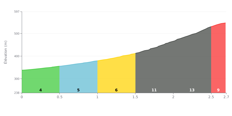
Difficulty analysis: The Przełęcz pod Świerkami, climbed from Lubiechów... wait, the source says Lubiechowa, so keep it as Lubiechowa. The Przełęcz pod Świerkami, climbed from Lubiechowa, is a short but demanding climb: 2.7 km for 208 m of elevation gain, with an average gradient of 7.7% that puts it in 2nd category. The difficulty lies mainly in how the gradient builds. The first two kilometres, between 4% and 5%, let you settle into the effort before the gradient ramps up to 11% between 1.5 and 2 km, then to 13% between 2 and 2.5 km. The final stretch at 9% from 2.5 to 2.7 km remains punishing after that intense section.
Tips for the effort:
1. Start conservatively. On the 0.0–0.5 km section at 4%, find a steady rhythm and don't let the easy gradient tempt you into burning matches, so you keep something in the tank.
2. Prepare for the steepest pitches. Between 1.5 and 2.5 km, where the gradient hits 11% then 13%, shift into an easier gear right at the start of the section and keep a smooth cadence to spare your legs.
3. Empty the tank on the finish. Over the last 172 m at 9%, ease off the pedal pressure but stay seated in position, and give everything you have left all the way to the summit.
The car park is on a dirt track in the middle of the forest, and it's easy to miss. If you're coming into Lubiechów from the left, you can't see it from the main road, and you need to have already gone past it to spot it. There's no "P" sign. One witness also points out that on the maps it's marked on the other side of the road, and that the snow isn't always cleared properly there.
The car park is free. It's small: about a dozen cars according to most witnesses, a few more according to one. The spaces are packed earth, with no shelter or benches. On a Saturday morning in August at 9 o'clock, it was empty. In spring it can get very muddy.
From the car park, a yellow-marked trail leads up to the Okole. Times vary: one hour for the whole thing according to one witness, around thirty minutes according to another, with a gentle gradient, part through forest and part across mountain meadow. The route is described as a family trail. The summit is a bit poorly marked, and one witness found rubbish up there.
From the viewing platform at the top, the view stretches over the Karkonosze and the Izery. For one witness, the Okole gives a good feel for the character of the Kaczawskie Mountains. Several describe the car park as a good starting point, on foot or by bike, for heading up there.
2.7 km • 208 m D+
VAM: average climbing speed, based on elevation gain


Join thousands of cycling fans! Plan your rides, record your performance, track your progress and discover the finest climbs.
Live climb profile to pace your effort all the way to the top.

