
Przełęcz Kowarska is a climb of 4.8 kilometers (category 4). The climb finishes at 726 m above sea level. It is located in Leszczyniec, województwo dolnośląskie, Polska. The average gradient is 3.2% with a maximum of 5.2%. The climb has 151 meters of elevation gain.
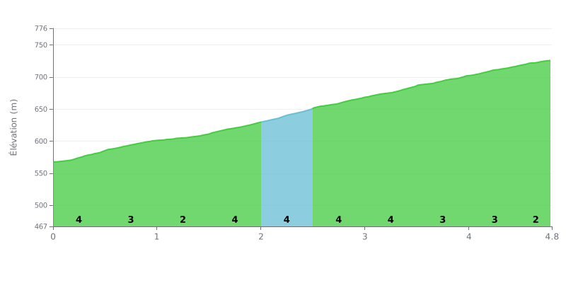
Difficulty analysis: Przełęcz Kowarska from Ogorzelec is a 4.8 km climb with 151 m of elevation gain, averaging 3.2% gradient, which puts it in category 4. There are no truly steep sections: eight of the ten segments sit between 3% and 4%, so it's doable for most regular riders. The real challenge is holding a steady effort over almost the entire climb, the only notable break being the km 1.0-1.5 segment at 2%.
Tips for managing your effort:
1. Pace the start The first 500 metres at 4% tempt you to go out too hard: settle into a steady rhythm from the bottom to save your legs for later.
2. Recover on the 2% section Make the most of the km 1.0-1.5 segment, the easiest part of the climb, to pick up your cadence again and take on some fluids before what's ahead.
3. Save something for the finish After the 4% ramps between km 2.0 and 2.5, keep some energy in the tank for the final km 4.5-4.8 stretch, which stays at 3% and still demands consistency.
On the road side, reviews describe a twisty climb, with lots of bends in both directions. Several riders find the tarmac decent, but others report potholes and a broken-up surface over the fourteen kilometres of road. One cyclist who did the climb hit a stretch of uneven surface, so it's worth checking the road condition before you set off.
The views come up most often. You can see Ogorzelec, Kowary, the Karkonosze and the Rudawy Janowickie. One person notes that the view only opens up on one side. Several say the scenery is worth a stop, even a short one, to catch your breath and take a photo. In winter the road can be slippery, and someone recommends keeping snow chains in the boot. In spring the car park turns to mud. You also need good weather for the panorama to be worth it.
The negatives are numerous and come up again and again. The car park costs 20 zł, payable only by BLIK. Signs mark the area as private land, but don't say where it starts or ends. One witness says the phone number given for payment didn't work. The car park is described as neglected, with litter, no bins, a gravelly surface and potholes. There is almost no infrastructure on site. All that remains of the old Schillerbaude refuge, demolished several decades ago, are the ruins.
If you want to extend your stop, the area has a few options. Mount Rudnik can be hiked in about 1.2 km, with an observation platform at the summit. Beneath the pass runs a railway tunnel from 1905, now closed. The trail toward the Mała Ostra also offers a great panorama over the Karkonosze. Finally, several cyclists and hikers report that just across the border, on the Czech side, you can find knedlíky and craft beer.
4.8 km • 151 m D+
VAM: average climbing speed, based on elevation gain


Join thousands of cycling fans! Plan your rides, record your performance, track your progress and discover the finest climbs.
Live climb profile to pace your effort all the way to the top.

