
Passo d'Azzurro is a climb of 22.0 kilometers (hors catégorie). Passo d'Azzurro tops out at 1,507 m above sea level. It is located in Lánov, Severovýchod, Česko. The average gradient is 4.9% with a maximum of 13.6%. The climb has 1086 meters of elevation gain.
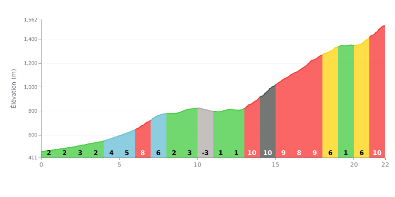
Difficulty breakdown: This 22 km climb has two faces. The first half (km 0-10) features moderate gradients (2-5%), ideal for settling into a rhythm. The real difficulty is concentrated in the second half, with a tough stretch between km 13 and 18 (9% to 11% gradients) and a hard finish (km 20-22 at 7-9%). The short descent at km 10-11 offers a strategic breather.
Tips for managing the effort:
1. Pacing: Resist the temptation to go too hard in the first easy km. The goal is to hit the 11% ramps (km 14) with something left in the tank.
2. Make the most of the breather: The short descent at km 10 is crucial. Use it to recover actively (soft pedaling) and mentally prepare for the hard section.
3. Save something for the finish: Even after km 18, the gradient stays significant. Hold some power for the last km at 9%, the steepest part of the climb along with km 13.
According to cyclists' accounts, the Sentiero Azzurro between Mergozzo and Montorfano is far more than a simple climb: it's a cool, shady immersion in woodland running alongside the lake. The track, an old mulattiera, is described as easy and accessible, with a modest climb of around 150 metres over about 3 km, making it doable for most riders, even with the family. The surface is mostly stones and dirt, so proper footwear is a must, but it's appreciated for its quiet and unspoiled character.
What makes this outing stand out, according to the reports, are the stunning views and the peaceful atmosphere. The route offers great viewpoints up high over Lake Mergozzo, crystal clear and intimate, with small streams and waterfalls here and there. Arriving in Montorfano, with its charming Romanesque church and small stone village, is a cultural reward and an ideal spot for a picnic break before heading back.
The reports also point out a few things to watch out for. The signage could be better in places, especially near the arrival by the tarmac road, where you need to spot where the track continues. In addition, some riders have come across private access signs along one section of the trail, which creates some confusion about whether you're allowed through. Finally, the last stretch to reach the centre of Montorfano briefly uses a small road with no cycling facilities, so caution is advised.
Despite these minor challenges, the overall experience is described as very enjoyable and refreshing. The mix of moderate effort, the coolness of the woods even in summer, the lakeside scenery and the charm of the surrounding villages make it a breath of fresh air, best summed up by one rider's account: an outing that lets you recharge your batteries.
22.0 km • 1086 m D+
VAM: average climbing speed, based on elevation gain


Join thousands of cycling fans! Plan your rides, record your performance, track your progress and discover the finest climbs.
Live climb profile to pace your effort all the way to the top.


Within 20 km