
Vrbatova Bouda is a climb of 20.1 kilometers (category 1). Vrbatova Bouda tops out at 1,379 m above sea level. It is located in Dolní Štěpanice, Severovýchod, Česko. The average gradient is 4.6% with a maximum of 10.4%. The climb has 929 meters of elevation gain.
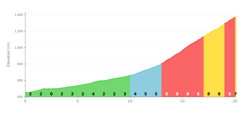
Difficulty breakdown: This climb has two distinct parts. The first 13 km are fairly moderate (average gradient of 2.4%), a long approach. The real difficulty is concentrated in the last 7 km, where the average gradient tops 8%. That's seriously steep and justifies its Category 1 rating.
Pacing tips:
1. Managing your pace on the first section: Use the first 13 km to find a steady rhythm without burning matches. The gentle gradient lets you spin along in an easy gear.
2. Anticipating the change of rhythm: From km 13 on, get ready mentally and physically for the significant jump in gradient (8-9%). Shift down progressively to keep a steady cadence.
3. Staying focused on the finale: The last few km hold a sustained 8% gradient. Avoid surges and concentrate on a steady breathing rhythm to get through these hard sections.
20.1 km • 929 m D+
VAM: average climbing speed, based on elevation gain


Join thousands of cycling fans! Plan your rides, record your performance, track your progress and discover the finest climbs.
Live climb profile to pace your effort all the way to the top.


Within 20 km