
Przełęcz Szklarska is a climb of 5.5 kilometers (category 3). The climb finishes at 887 m above sea level. It is located in Harrachov, Liberecký kraj, Česko. The average gradient is 4.4% with a maximum of 7.9%. The climb has 242 meters of elevation gain.
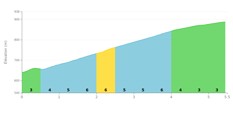
Climb analysis: This 5.5 km climb with 242 m of elevation gain averages 4.4%, which makes it a Category 3 climb. The profile is very even: the first half-kilometre, at 3%, is a gentle leg-opener, then the gradient bounces between 5% and 6% up to km 4.0. There's no single steep wall, just a string of sustained sections, the hardest being between km 1.5 and 2.5 and between km 3.5 and 4.0. The final part is easier between km 4.0 and 5.5 (4% then 3%), giving you a chance to recover before the summit.
Tips for riding it:
1. Pace yourself from the bottom. On the 0.0-0.5 km section at 3%, keep it below your threshold so you have something left for the 6% ramps between km 1.5 and 2.5.
2. Hold a steady rhythm. On the 5% and 6% sections (km 0.5 to 4.0), pick a gear that lets you spin smoothly rather than mashing in surges.
3. Pick up the pace in the final section. Between km 4.0 and 5.0, where the gradient drops to 4% then 3%, raise your cadence a little and finish the col with some power.
Those who have climbed this pass mostly talk about the scenery. On site, there's an old border crossing and a conifer forest, typical of the Izera Mountains.
Access is easy, with a car park right nearby. One rider also mentions a small shop set up at the border.
One rider has known the spot since childhood and comes back often when he's in the area. For him, it's a trip back to the years gone by, and he recommends it.
The other reviews are short: they like it, it's beautiful, it's good. They say almost nothing about the climb itself, its gradient or the state of the road, so it's best to get a feel for it on the ground.
5.5 km • 242 m D+
VAM: average climbing speed, based on elevation gain


Join thousands of cycling fans! Plan your rides, record your performance, track your progress and discover the finest climbs.
Live climb profile to pace your effort all the way to the top.

