
Przełęcz Marszałka Edwarda Rydza-Śmigłego is a climb of 6.8 kilometers (category 3). The climb finishes at 694 m above sea level. It is located in Słopnice, województwo małopolskie, Polska. The average gradient is 3.8% with a maximum of 10.5%. The climb has 255 meters of elevation gain.
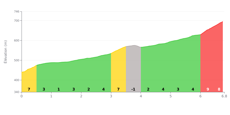
Difficulty breakdown: At 6.8 km for 255 m of elevation gain, with an average gradient of 3.8%, this 3rd category climb is doable but demands a steady rhythm. The opening (0.0-0.5 km) at 7% sets the tone, then the road alternates between rolling sections at 1-3% (1.0-2.5 km) and steeper pitches. The hardest kilometers are 3.0-3.5 km at 7% and, above all, 6.0-6.8 km, where the gradient hits 9% and then 8% just before the summit. The short descent (3.5-4.0 km, -1%) offers a welcome bit of recovery.
Pacing tips:
1. Don't go out too hard. The first 500 metres at 7% will tempt you to force the pace, so settle into a steady rhythm from the start to keep something in the tank.
2. Recover on the false flats. Use the 1% to 3% stretches (1.0 to 2.5 km) to eat, drink and relax your shoulders.
3. Save something for the finish. Between 6.0 and 6.8 km, shift into an easier gear, stay seated if you can, and hold your cadence all the way to the top.
The reports mostly focus on the starting point for hikes. The pass sits between the Łopień and the Mogielica, in the Beskid Wyspowy. Lots of people stop here to tackle the Mogielica, and one rider calls it the shortest way up. Views come up again and again, in both directions, with the Beskid ranges stretching out as far as you can see.
A cross carries an inscription recalling that Polish legionnaires, under Józef Piłsudski, fought here in November 1914 and captured a Russian cavalry detachment. It was put up in 1928. Another rider mentions a 1938 monument. A few metres further on, a table and benches make a good spot for a break.
Parking is the most frequent topic. There's a small free lot by the road, and a paid car park with a barrier at 4 zł an hour, or 15 zł beyond three hours according to one rider. Watch out for spots on private land: one cyclist ended up paying without realising after missing the free spaces, and another considers the spot risky for parking. On Sundays the lot and the verges are packed in the morning, a bit less so in the afternoon. In August, around 9 a.m., there were still free spaces.
Nearby, there are a few small houses and a food complex. One rider mentions a small wood laid out for walking. A loop is possible, climbing by one trail and descending by another. In winter, the site serves as a starting point for cross-country skiing. The reports say very little about the road itself: nothing on its condition, traffic, or gradient. A single mention of a "fajny podjazd" (a nice climb) from Jurków, with no further detail.
6.8 km • 255 m D+
VAM: average climbing speed, based on elevation gain


Join thousands of cycling fans! Plan your rides, record your performance, track your progress and discover the finest climbs.
Live climb profile to pace your effort all the way to the top.


Other climbs to Przełęcz Marszałka Edwarda Rydza-Śmigłego
Within 20 km