
Rysia Góra is a climb of 3.6 kilometers (category 1). The climb finishes at 638 m above sea level. It is located in Limanowa, województwo małopolskie, Polska. The average gradient is 7.4% with a maximum of 16.9%. The climb has 270 meters of elevation gain.
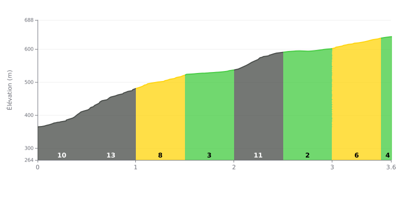
Difficulty breakdown: The Rysia Góra from Łososina Górna is a serious climb: 3.6 km at 270 m of elevation gain, with an average gradient of 7.4%, which earns it a Category 1 ranking. The real pain is concentrated in two very steep sections, km 0.5 to 1.0 at 13% and km 2.0 to 2.5 at 11%, after an already punchy start at 10% from km 0.0 to 0.5. The more rolling stretches, km 1.5 to 2.0 at 3% and km 2.5 to 3.0 at 2%, give you useful breathers. The final part, km 3.0 to 3.5 at 6%, still hurts after the effort you've already put in.
Tips for pacing yourself:
1. Ease into it. The first 500 metres at 10% will tempt you to go out too hard: find a rhythm from the bottom that you can hold all the way to the summit.
2. Get over the 13% walls while keeping your cadence. From km 0.5 to 1.0, stay seated if you can, pick a gear you can spin in, and keep a smooth cadence without grinding on the pedals.
3. Recover on the false flats. Use the 3% section (km 1.5 to 2.0) and the 2% section (km 2.5 to 3.0) to catch your breath and tackle the 6% finale with something left in the tank.
Those who have ridden up Paproć describe a paved road, but narrow, twisty and steep in places. Many advise taking it easy on the descent. In summer, any car can make it to the top, whereas in winter, without a 4x4 or chains, the climb gets tough. Motorcyclists are happy with the ascent, and some prefer to come back down by another road.
On foot or on the bike, the most recommended route is the green trail from Tymbark. Riders say it's easy and not too long, with a section through beech and fir forest, then clearings. Once you're out of the trees, you can see Mogielica, Łopień, Śnieżnica and Ćwilin. The Tatras only show up when the weather is clear, and Babia Góra is sometimes visible in the distance.
At the top there's a chapel, a big metal cross that's visible from far away, a wiata (shelter), a car park, benches, a picnic table and an educational trail. Several riders were caught out by the viewpoint sign, which doesn't mark the true summit: that's another 200 to 300 metres further on, in the forest, on the west side.
The downsides come up often. Several people complain about litter left behind. You also need to watch out for electric fences (pastuchy) when heading down toward the neighbouring meadow. Finally, one witness feels the place is poorly set up for the number of visitors.
3.6 km • 270 m D+
VAM: average climbing speed, based on elevation gain


Join thousands of cycling fans! Plan your rides, record your performance, track your progress and discover the finest climbs.
Live climb profile to pace your effort all the way to the top.


Within 20 km