
Cisowy Dział is a climb of 4.5 kilometers (category 1). The climb finishes at 794 m above sea level. It is located in Kicznia, województwo małopolskie, Polska. The average gradient is 7.3% with a maximum of 19.5%. The climb has 328 meters of elevation gain.
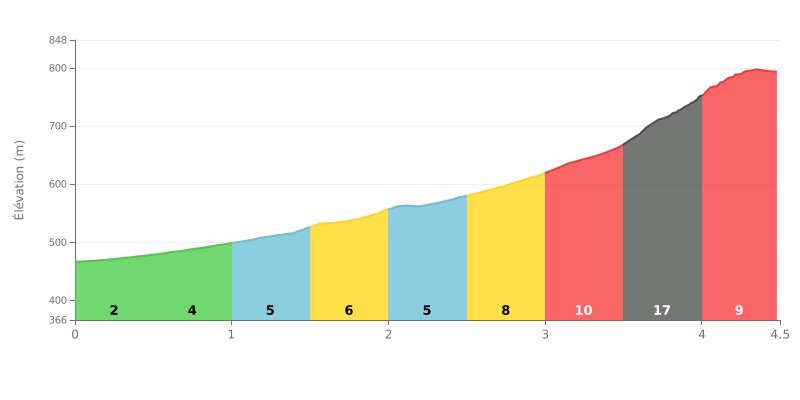
Difficulty analysis: The Cisowy Dział is a climb of 4.5 km for 328 m of elevation gain, with an average gradient of 7.3%, which earns it a Category 1 rating. The first few kilometres stay manageable between 3 and 6%, but the gradient rises to 8% between km 2.5 and 3.0, then to 10% between km 3.0 and 3.5. The section from km 3.5 to 4.0, at 17%, is the key point of the climb, followed by a final kilometre still tough at 9%.
Tips for pacing your effort:
1. Control the start Don't get carried away by the gentler gradients at the beginning, and hold a steady rhythm so you have something left for the second half.
2. Prepare for the 17% section Shift into an easy gear before km 3.5 and stay seated to keep a smooth, consistent cadence without blowing up.
3. Don't let up on the final kilometre On the last kilometre at 9%, keep pushing all the way to the summit, because that's where many climbers lose places.
The pass sits at the end of a narrow, very steep little road. Several people have driven up in summer without any trouble, but if you're in a wider vehicle, it's worth thinking twice. In winter, according to one report, only a 4x4 makes it up.
On the bike, starting from the Młyńczyska side, the gradients are brutal in places. One rider describes the climb as tough, with some really steep ramps. The descent toward Łącko is just as steep, and someone warns that you need good brakes if you want to keep it under control.
The view is what people mention most. You can see the Tatras, with the Gorce and the Beskids around them. Many say the panoramas make you forget the effort of the climb.
Up top, it's quiet, and the silence is what you notice most. There's a small chapel, a Way of the Cross with stone stations, a shelter and some benches. People come to pray too, especially at Easter. The car park fits about ten cars. It's also a good starting point for a hike up to the Modyń: the trail is short but steep, roughly half an hour to the tower, and on the way back, on wet ground, it can get slippery. A family with young kids found the walk suitable.
4.5 km • 328 m D+
VAM: average climbing speed, based on elevation gain


Join thousands of cycling fans! Plan your rides, record your performance, track your progress and discover the finest climbs.
Live climb profile to pace your effort all the way to the top.


Within 20 km