
Rysia Góra is a climb of 4.6 kilometers (category 2). The climb finishes at 638 m above sea level. It is located in Limanowa, województwo małopolskie, Polska. The average gradient is 5.6% with a maximum of 18.5%. The climb has 258 meters of elevation gain.
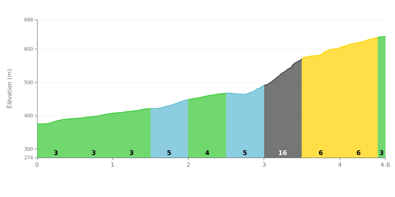
Difficulty analysis: This 4.6 km climb with 258 m of elevation gain averages 5.6%, making it a demanding col that is still within reach of well-trained riders. Between KM 0.0 and KM 3.0, the gradient fluctuates between 3% and 5%, which makes it easy to find a steady rhythm. The real crux comes at KM 3.0-3.5 with a 16% ramp over 493 m, which alone accounts for 80 m of climbing. The final section, over KM 3.5-4.0 and 4.0-4.5 at 6%, requires you to keep some strength in the tank after that tough stretch.
Tips for the effort:
1. Pace yourself from the bottom. On KM 0.0-1.5, where the gradient stays around 3%, resist the urge to attack and settle into a steady cadence to save your legs.
2. Prepare for the ramp. Shift into an easier gear before KM 3.0-3.5 at 16%, stay seated, and keep a smooth cadence so you don't blow up.
3. Finish with consistency. On KM 3.5-4.0 and 4.0-4.5 at 6%, get back into a constant rhythm without easing off, since the relief after the ramp can tempt you to overextend yourself.
Those who have ridden up Paproć describe a paved road, but narrow, twisty and steep in places. Many advise taking it easy on the descent. In summer, any car can make it to the top, whereas in winter, without a 4x4 or chains, the climb gets tough. Motorcyclists are happy with the ascent, and some prefer to come back down by another road.
On foot or on the bike, the most recommended route is the green trail from Tymbark. Riders say it's easy and not too long, with a section through beech and fir forest, then clearings. Once you're out of the trees, you can see Mogielica, Łopień, Śnieżnica and Ćwilin. The Tatras only show up when the weather is clear, and Babia Góra is sometimes visible in the distance.
At the top there's a chapel, a big metal cross that's visible from far away, a wiata (shelter), a car park, benches, a picnic table and an educational trail. Several riders were caught out by the viewpoint sign, which doesn't mark the true summit: that's another 200 to 300 metres further on, in the forest, on the west side.
The downsides come up often. Several people complain about litter left behind. You also need to watch out for electric fences (pastuchy) when heading down toward the neighbouring meadow. Finally, one witness feels the place is poorly set up for the number of visitors.
4.6 km • 258 m D+
VAM: average climbing speed, based on elevation gain


Join thousands of cycling fans! Plan your rides, record your performance, track your progress and discover the finest climbs.
Live climb profile to pace your effort all the way to the top.


Within 20 km