
Przełęcz Przysłopek is a climb of 2.7 kilometers (category 2). The climb finishes at 779 m above sea level. It is located in Lubomierz, województwo małopolskie, Polska. The average gradient is 7.4% with a maximum of 20.2%. The climb has 202 meters of elevation gain.
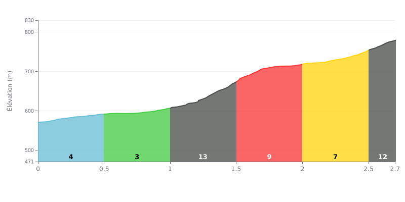
Difficulty breakdown: With 2.7 km for 202 m of elevation gain and an average gradient of 7.4%, the Przełęcz Przysłopek is rated Category 2. The start, from KM 0.0 to KM 1.0, is rolling at 4% then 3%. The real difficulty comes next, between KM 1.0 and KM 1.5 at 14%, the true crux of the climb, before a more steady section at 9% then 7%. The KM 2.5-2.7 stretch at 12% demands one last push to the summit.
Tips for pacing yourself:
1. Save your legs at the bottom On the KM 0.0-0.5 section at 4%, spin an easy gear and roll in fresh for the 14% ramp.
2. Manage your gearing between KM 1.0 and 1.5 Shift down to a small chainring as soon as the 14% ramp starts, stay seated and keep a steady cadence rather than mashing the pedals.
3. Save something for the finish The KM 2.5-2.7 stretch at 12% is short but steep, so hold back a final acceleration for the last few hundred metres to the summit.
Riders who have passed through Przełęcz Przysłopek mostly describe the pass as a good starting point. Several say you can set off from there for Jasień, or towards the Kutrzyca or the Myszyca, and that there is also the Dziedziny de Zagórze monument on Polana Nowa. In spring there are loads of crocuses.
The car park is small. It sits on private land, marked with a P sign, and costs 10 zł per day, payable in cash or by BLIK. One rider says you can park up and head out on foot straight away, no dawdling.
The vibe comes up a lot in people's accounts. They describe a calm and quiet spot where you can lie back in the meadow grass and take in the view. The reports say nothing specific about the road surface, the traffic or how hard the climb is on the bike, so it's worth checking those points before you set off.
One rider says it's the fastest route to Jasień. Overall, people who've been there recommend it.
2.7 km • 202 m D+
VAM: average climbing speed, based on elevation gain


Join thousands of cycling fans! Plan your rides, record your performance, track your progress and discover the finest climbs.
Live climb profile to pace your effort all the way to the top.


Within 20 km