
Côte de Rideux is a climb of 2.6 kilometers (category 3). Côte de Rideux tops out at 365 m above sea level. It is located in Aisne, Luxembourg, België / Belgique / Belgien. The average gradient is 7.7% with a maximum of 13.4%. The climb has 204 meters of elevation gain.
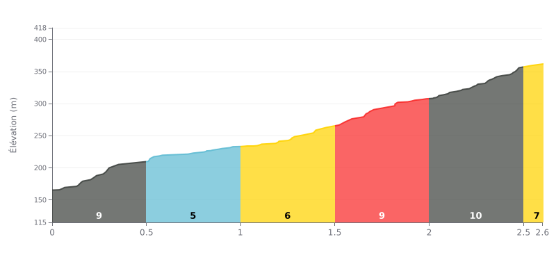
Difficulty analysis: This 2.6 km climb has a progressive difficulty. The first part is uneven (9%, then 5%), but the finale is the hardest, with 10% gradient over the last 500 meters. The 8% average gradient is significant over this distance, confirming its classification as a Cat 3 climb.
Tips for managing your effort:
1. Managing the start: Resist the urge to go too hard on the opening 9% slope. Settle into a steady rhythm to save your legs.
2. Making the most of the breather: Use the easiest section (5% between 0.5 and 1.0 km) to recover and adjust your pace before the tougher parts.
3. Saving something for the finish: Keep some reserves for the last 500 meters at 10%, the steepest section. Gradually increase your effort from the 2.0 km mark.
2.6 km • 204 m D+
VAM: average climbing speed, based on elevation gain


Join thousands of cycling fans! Plan your rides, record your performance, track your progress and discover the finest climbs.
Live climb profile to pace your effort all the way to the top.


Within 20 km