
Côte de Hogister is a climb of 3.4 kilometers (category 3). Côte de Hogister tops out at 394 m above sea level. It is located in Warisy, Luxembourg, België / Belgique / Belgien. The average gradient is 4.7% with a maximum of 9.4%. The climb has 160 meters of elevation gain.
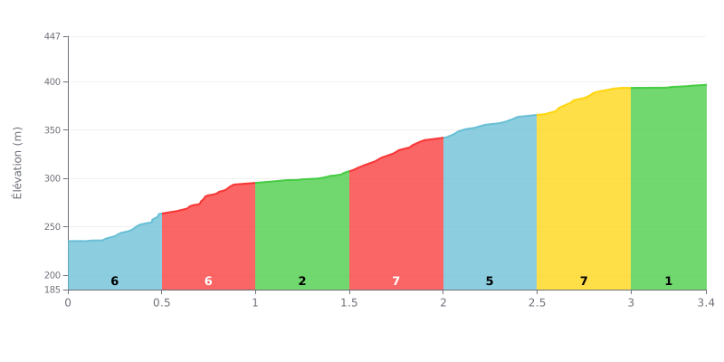
Difficulty breakdown: This Category 3 climb is moderately hard. The 5% average gradient is pretty standard, but the way it's distributed gives you two harder sections at 7% (between 0.5-1.0 km and 1.5-2.0 km), and those are the key sections. The finish is very easy (1% over the last 400 metres), so you get some active recovery there.
Tips for pacing your effort:
1. Managing the two 7% sections: Plan ahead for the two 7% stretches. Hit the first one (0.5-1.0 km) without being gassed, and go into the second one (1.5-2.0 km) with some legs left.
2. Recovering on the easier stretches: Use the sections with lower gradient (3% around 1.0-1.5 km and 1% at the end) to ease off the intensity a little and get your breathing back under control.
3. Keeping a steady rhythm: Hold a consistent effort, a bit under your threshold on the 5% sections, and you'll keep your heart rate in check through the two steep kicks.
3.4 km • 160 m D+
VAM: average climbing speed, based on elevation gain


Join thousands of cycling fans! Plan your rides, record your performance, track your progress and discover the finest climbs.
Live climb profile to pace your effort all the way to the top.


Other climbs to Côte de Hogister