
Roche-à-Frêne is a climb of 2.2 kilometers (category 2). Roche-à-Frêne tops out at 367 m above sea level. It is located in Manhay, Luxembourg, België / Belgique / Belgien. The average gradient is 8.7% with a maximum of 12%. The climb has 189 meters of elevation gain.
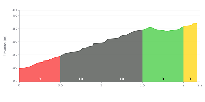
Difficulty analysis: This climb is only 2.2 km long, but it's short and punchy. The real challenge lies in its first three half-kilometres at 10% gradient, which account for almost 80% of the total elevation gain on their own. The middle section (1.5–2.0 km) at 3% offers a welcome breather before a steeper finish at 7%.
Tips for managing your effort:
1. Start controlled: Don't let the opening gradient fool you. Settle into a steady rhythm from the bottom to avoid blowing up on the 10% sections.
2. Make the most of the breather: Use the 3% section (between 1.5 and 2.0 km) to recover by easing off the pedal pressure and shifting gears, without slowing down too much.
3. Save something for the end: The final 7% stretch requires keeping some energy in reserve. Shift into an easier gear before it and keep your cadence up all the way to the summit.
2.2 km • 189 m D+
VAM: average climbing speed, based on elevation gain


Join thousands of cycling fans! Plan your rides, record your performance, track your progress and discover the finest climbs.
Live climb profile to pace your effort all the way to the top.


Within 20 km