
Hebron Har is a climb of 18.0 kilometers (category 1). Hebron Har tops out at 821 m above sea level. It is located in מועצה אזורית יואב, מחוז הדרום, ישראל. The average gradient is 3.2% with a maximum of 12.8%. The climb has 571 meters of elevation gain.
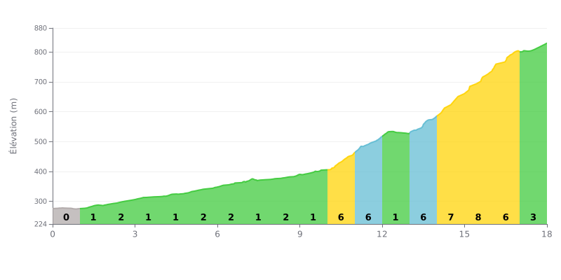
Difficulty analysis: This 1st category climb has a two-part profile. The first 10 kilometers are fairly gentle (average gradient of 1-2%), giving you a chance to find your rhythm. The real difficulty is concentrated in the second half, with a series of steep ramps between kilometers 10 and 17 (5% to 8%), accounting for most of the total elevation gain.
Tips for managing your effort:
1. Pace the start: Use the first 10 kilometers to warm up your legs without going too hard. Don't overestimate your pace on this easy section.
2. Save something for the wall: Keep some energy in reserve to attack the hard section from KM 10 onward. That's where the climb really begins.
3. Managing your power: On the 6-8% ramps, adjust your gear to keep a steady cadence and avoid blowing up on the steepest pitches.
18.0 km • 571 m D+
VAM: average climbing speed, based on elevation gain


Join thousands of cycling fans! Plan your rides, record your performance, track your progress and discover the finest climbs.
Live climb profile to pace your effort all the way to the top.

