
Agria is a climb of 6.7 kilometers (category 1). Agria tops out at 463 m above sea level. It is located in Δήμος Βόλου, Αποκεντρωμένη Διοίκηση Θεσσαλίας - Στερεάς Ελλάδος, Ελλάς. The average gradient is 7.2% with a maximum of 16.8%. The climb has 482 meters of elevation gain.
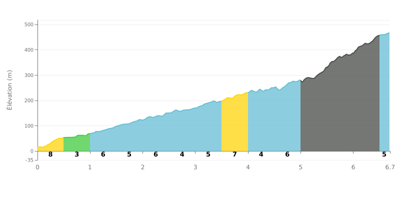
Difficulty breakdown: This Cat 1 climb ramps up gradually. The first half (0-3.5 km) is fairly mild, with gradients between 3% and 7%. Things get serious after the 5th kilometer, with a punchy 11% section (KM 5.0-5.5), another 11% (KM 5.5-6.0), and a maximum of 14% (KM 6.0-6.5) before it eases off toward the top.
How to manage the effort:
1. Pacing: Save your legs for the first 5 km. The real effort belongs in the critical section between 5.0 and 6.5 km.
2. Anticipate the gradient changes: With 11% and 14% pitches, shift into an easier gear early so you don't blow up when the road kicks up.
3. Mental chunking: Split the climb into two parts: the approach (km 0-5) and the wall (km 5-6.5). Treat the last 200 meters as active recovery.
6.7 km • 482 m D+
VAM: average climbing speed, based on elevation gain


Join thousands of cycling fans! Plan your rides, record your performance, track your progress and discover the finest climbs.
Live climb profile to pace your effort all the way to the top.

