
Ag. Georgios Nilias is a climb of 10.1 kilometers (hors catégorie). Ag. Georgios Nilias tops out at 694 m above sea level. It is located in Δημοτική Ενότητα Μηλεών, Αποκεντρωμένη Διοίκηση Θεσσαλίας - Στερεάς Ελλάδος, Ελλάς. The average gradient is 7.0% with a maximum of 14%. The climb has 710 meters of elevation gain.
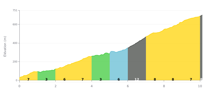
Difficulty breakdown: This 10.1 km HC climb is genuinely hard despite an average gradient of 7%. The real challenge is its irregularity, with a brutal stretch between km 6 and 9. The 6.0-7.0 km section, at 12% (121m of climbing), is the key point where your rhythm can fall apart.
How to manage the effort:
1. Pacing the middle section: Save your legs on the 3% sections (km 1-2 and 4-5) so you hit the 12% wall with something left in the tank.
2. Prepare for the steepest part: Get your head and your gearing sorted before km 6 so you can get over the 12% without surging or grinding.
3. Keep pushing after the peak: The gradient stays high (8%) for the next two kilometres, so don't ease off once you've passed the hardest part.
10.1 km • 710 m D+
VAM: average climbing speed, based on elevation gain


Join thousands of cycling fans! Plan your rides, record your performance, track your progress and discover the finest climbs.
Live climb profile to pace your effort all the way to the top.

