
Zagora is a climb of 9.2 kilometers (category 1). Zagora tops out at 451 m above sea level. It is located in Δημοτική Ενότητα Ζαγοράς, Αποκεντρωμένη Διοίκηση Θεσσαλίας - Στερεάς Ελλάδος, Ελλάς. The average gradient is 5.0% with a maximum of 9.2%. The climb has 465 meters of elevation gain.
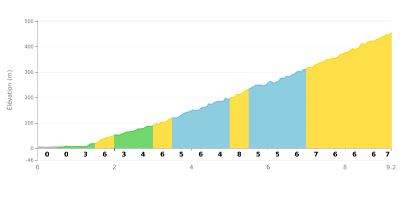
Difficulty breakdown: This Category 1 climb is genuinely tough because of its uneven profile. The first section (KM 0-2) is very gentle, but the gradient steadily ramps up to key stretches at 7-8% (KM 5.0-5.5 and KM 8.0-9.2). At 9.2 km long, with sustained climbing after KM 2, it's a proper sustained grind.
Pacing tips:
1. Pacing the start: Use the first 2 km of easy gradient to settle into a steady rhythm and avoid going out too hard.
2. Prepare for the steep sections: The 8% stretches (around KM 5 and in the finale) demand more out of your legs. Drop into a slightly easier gear as you approach them to keep your cadence up.
3. Hold a steady effort: The 5% average gradient is deceptive. Focus on a constant effort rather than your speed, which will fluctuate as the gradient changes.
9.2 km • 465 m D+
VAM: average climbing speed, based on elevation gain


Join thousands of cycling fans! Plan your rides, record your performance, track your progress and discover the finest climbs.
Live climb profile to pace your effort all the way to the top.

