
Tizi n'tagha is a climb of 22.8 kilometers (hors catégorie). Tizi n'tagha tops out at 1,256 m above sea level. It is located in Taskriout, Béjaïa, Algérie ⵍⵣⵣⴰⵢⴻⵔ الجزائر. The average gradient is 5.5% with a maximum of 15.3%. The climb has 1242 meters of elevation gain.
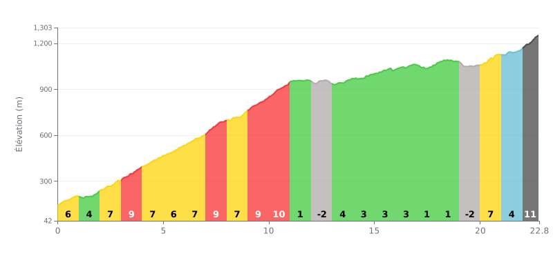
Difficulty analysis: At 22.8 km for 1242 m of elevation gain and an average gradient of 5.5%, this climb is rated hors catégorie (HC) and demands a long, sustained effort. The difficulty is concentrated in the first half, with sections between 6% and 10% from km 0 to km 11. The steepest parts are km 3-4 and km 7-8 (9%), km 9-10 (9%) and km 10-11 (10%). From km 11 to km 19, the gradient eases noticeably, with a false flat and a short descent that give you a breather before the finale. The last section, with 7% from km 20 to 21, 4% from km 21 to 22, then 11% over the final 800 metres, is particularly demanding.
Tips for pacing yourself:
1. Managing the start Don't go out too hard on the 6% to 9% gradients between km 0 and km 10: a steady rhythm will save your legs for the end of the climb.
2. Making the most of the breather Between km 11 and km 19, spin the pedals easily, drink and eat to refill your reserves before the 7% and then the 4% sections.
3. Tackling the final On the last 800 metres at 11%, shift into an easy gear, stay seated as much as possible and keep a high cadence to limit muscle fatigue.
22.8 km • 1242 m D+
VAM: average climbing speed, based on elevation gain


Join thousands of cycling fans! Plan your rides, record your performance, track your progress and discover the finest climbs.
Live climb profile to pace your effort all the way to the top.


Other climbs to Tizi n'tagha