
Tizi n'tagha is a climb of 12.4 kilometers (hors catégorie). Tizi n'tagha tops out at 1,256 m above sea level. It is located in Tala Ifacene, سطيف, Algérie ⵍⵣⵣⴰⵢⴻⵔ الجزائر. The average gradient is 5.9% with a maximum of 16.1%. The climb has 731 meters of elevation gain.
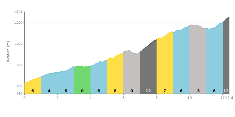
Difficulty breakdown: Tizi n'tagha from Takendoukt is a hors catégorie climb, 12.4 km long, averaging 5.9% over 731 m of elevation gain. The profile is fairly steady, with stretches at 6% for much of the way, but the km 7.0-8.0 section at 12% and the finishing km 12.0-12.4, also at 12%, are the real crux. The flat sections at km 3.0-4.0 and 6.0-7.0 give you a few moments of respite, and the -3% descent between km 10.0 and 11.0 lets you shake out your legs before the last part. It's a long, demanding effort, so you'll need to manage it carefully from start to finish.
Tips for riding it:
1. Pace yourself from the bottom On the 6% section from km 0.0-1.0, keep a controlled tempo so you still have your head together when you reach km 7.0-8.0.
2. Make the most of the flats Use the flat at km 6.0-7.0 to eat, drink and get back into the bunch, without surging for no reason.
3. Hold your form in the final push On the km 12.0-12.4 section at 12%, spin a smooth cadence, stay seated and hold your rhythm all the way to the line.
12.4 km • 731 m D+
VAM: average climbing speed, based on elevation gain


Join thousands of cycling fans! Plan your rides, record your performance, track your progress and discover the finest climbs.
Live climb profile to pace your effort all the way to the top.


Other climbs to Tizi n'tagha