
Gunung Kucir is a climb of 6.8 kilometers (hors catégorie). The climb finishes at 669 m above sea level. It is located in Purwoharjo, Daerah Istimewa Yogyakarta, Indonesia. The average gradient is 8.6% with a maximum of 18.6%. The climb has 583 meters of elevation gain.
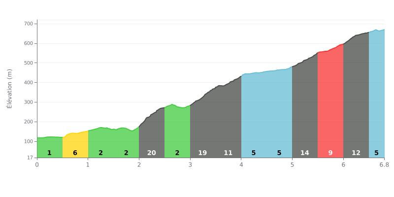
Difficulty breakdown: Gunung Kucir from Kedungrong is an HC climb covering 6.8 km with 583 m of elevation gain, at an average gradient of 8.6%. The start is fairly moderate, but km 2.0-2.5 hits 19%, followed by km 3.0-3.5 at 18%, which marks the first real break. The second half gives you little respite, with 14% at km 5.0-5.5 and 12% at km 6.0-6.5. This is a demanding climb, and it's decided more by how you manage your effort than by raw power alone.
Tips for managing your effort:
1. Pace yourself from the start The first kilometres are manageable, so keep a steady rhythm to reach the 19% section at km 2.0-2.5 with fresh legs.
2. Recover on the 2% section Km 2.5-3.0, at just 2%, is the ideal moment to catch your breath and get back in position before the 18% wall at km 3.0-3.5.
3. Save something for the finish Between km 5.0 and 6.5, the 14%, 9% and 12% gradients call for a steady cadence and a gear light enough that you don't grind to a halt.
6.8 km • 583 m D+
VAM: average climbing speed, based on elevation gain


Join thousands of cycling fans! Plan your rides, record your performance, track your progress and discover the finest climbs.
Live climb profile to pace your effort all the way to the top.


Other climbs to Gunung Kucir