
Gunung Kucir is a climb of 6.2 kilometers (hors catégorie). The climb finishes at 669 m above sea level. It is located in Kalibawang, Daerah Istimewa Yogyakarta, Indonesia. The average gradient is 9.2% with a maximum of 20.3%. The climb has 570 meters of elevation gain.
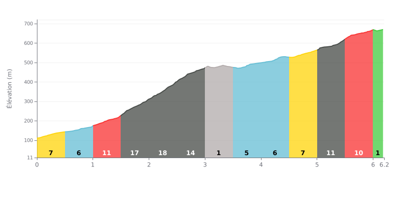
Climb analysis: At 6.2 km, 570 m of elevation gain and an average gradient of 9.2%, Gunung Kucir from Degan Dua is a brutal HC climb. The hardest section is between KM 1.5 and KM 3.0, where the gradient hits 17%, 18% and then 14% over more than 1.5 km. After the flat section at KM 3.0-3.5 at 0%, the finish stays punchy, with 10% and 11% stretches between KM 5.0 and 6.0, which grinds your legs down over time.
Pacing tips:
1. Start easy. From KM 0.0-1.0, at 7% then 6%, keep a steady rhythm so you reach the 17-18% ramps with fresh legs and something left in the tank.
2. Use the flat. At KM 3.0-3.5, at 0%, sit up, recover, drink, and ease back into the pedals to find your cadence again before the ramp.
3. Save it for the finish. Between KM 5.0 and 6.0, at 10-11%, spin a smooth cadence in a small gear and save some energy for the last few hundred metres at 1%.
6.2 km • 570 m D+
VAM: average climbing speed, based on elevation gain


Join thousands of cycling fans! Plan your rides, record your performance, track your progress and discover the finest climbs.
Live climb profile to pace your effort all the way to the top.


Other climbs to Gunung Kucir