
Gunung Kucir is a climb of 9.1 kilometers (hors catégorie). The climb finishes at 669 m above sea level. It is located in Pendoworejo, Daerah Istimewa Yogyakarta, Indonesia. The average gradient is 6.4% with a maximum of 19%. The climb has 581 meters of elevation gain.
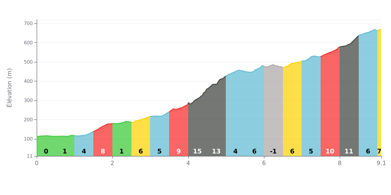
Climb analysis: At 9.1 km with 581 m of elevation gain and an average gradient of 6.4%, this climb is rated HC and demands a solid level of fitness. The profile is uneven: the first half alternates between rolling sections and moderate grades, then KM 4.0-5.0 concentrates the hardest stretch with 15% followed by 13%. The final third remains tough, with 10% (KM 7.5-8.0) and 12% (KM 8.0-8.5).
Pacing advice:
1. Keep an even pace from the start. The opening kilometres (KM 0.0-1.0) are almost flat, which tempts you to go out too hard. Hold a steady cadence to save your legs.
2. Prepare for the KM 4.0 to KM 5.0 section. Shift into an easy enough gear as you approach the 15% of KM 4.0-4.5, and favour a smooth cadence over out-of-the-saddle surges.
3. Manage your effort for the finish. Use the short respite at KM 6.0-6.5 (-1%) to recover, and keep something in the tank for the ramps of KM 7.5-8.5 before the final 6% (KM 8.5-9.0).
9.1 km • 581 m D+
VAM: average climbing speed, based on elevation gain


Join thousands of cycling fans! Plan your rides, record your performance, track your progress and discover the finest climbs.
Live climb profile to pace your effort all the way to the top.


Other climbs to Gunung Kucir