
Gunung Kucir is a climb of 5.2 kilometers (hors catégorie). The climb finishes at 669 m above sea level. It is located in Purwoharjo, Daerah Istimewa Yogyakarta, Indonesia. The average gradient is 10.0% with a maximum of 18.7%. The climb has 524 meters of elevation gain.
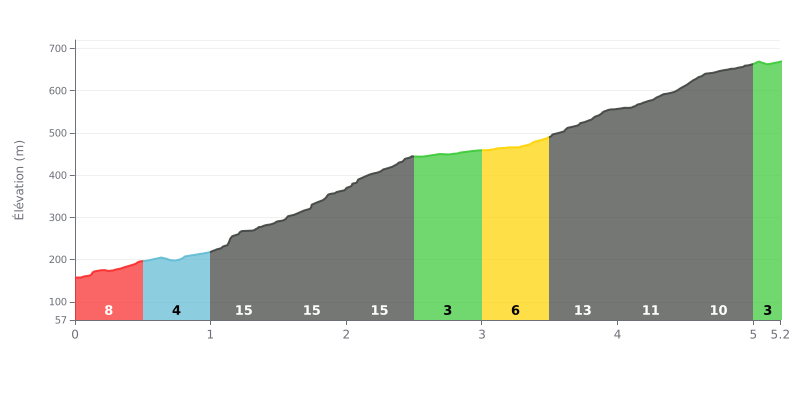
Difficulty breakdown: The Gunung Kucir from Besole is a hors catégorie climb: 5.2 km with 524 m of elevation gain, averaging 10%. The real pain is between km 1.0 and 2.5, with gradients of 14%, 17% and then 15%, and the 1.5-2.0 section is the nastiest of the lot. Breaks are rare and short, like the 4% at km 0.5-1.0 or the 3% at km 2.5-3.0, so you're on the pedals the whole way.
Pacing tips:
1. Ease into it: Don't get carried away over the first 500 metres at 8%, because the 14 to 17% ramps from km 1.0 to km 2.5 are where the climb really tests you.
2. Make the most of the easier stretches: Use the 4% section (km 0.5-1.0) and the 3% section (km 2.5-3.0) to recover and get your cadence back to a smooth rhythm.
3. Manage the finish: Between km 3.5 and 5.0, where the gradient varies from 13% down to 10%, stay seated and keep a steady cadence, then dig in on the 2% final stretch.
5.2 km • 524 m D+
VAM: average climbing speed, based on elevation gain


Join thousands of cycling fans! Plan your rides, record your performance, track your progress and discover the finest climbs.
Live climb profile to pace your effort all the way to the top.


Other climbs to Gunung Kucir