
Przełęcz Karkonoska (via Borowice) is a climb of 8.2 kilometers (category 2). Przełęcz Karkonoska (via Borowice) tops out at 1,196 m above sea level. It is located in Špindlerův Mlýn, Severovýchod, Česko. The average gradient is 5.4% with a maximum of 6.9%. The climb has 444 meters of elevation gain.
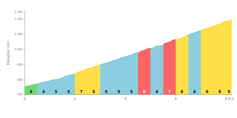
Difficulty analysis: This 8.2 km climb is steady rather than brutal. There's no extreme section, but there's no real respite either. The average gradient of 5.4% is sustained, and the profile shows a harder second half, with 6-7% grades dominating from KM 5.5 onwards. With no stretch below 4%, it's an honest Category 2 climb.
Tips for pacing the climb:
1. Managing your pace over the distance: Don't get caught out by the relatively "gentle" start. Settle into a steady rhythm you can hold for the full 8 km, and save something in the tank for the steeper final 3 km.
2. Anticipating the gradient changes: Pay close attention to the transition from KM 5.0 to KM 5.5, where the gradient jumps from 4% to 7%. Lifting your effort slightly as you approach this ramp will help you keep your cadence.
3. Riding efficiently: With a moderate average gradient, staying out of the saddle isn't necessarily the most efficient choice. Sit down and stay settled for better energy management over the length of the climb.
For the riders who've climbed it, Przełęcz Karkonoska is a col with character. Reports agree on one point: the scenery is breathtaking, with "piękne widoki" (beautiful views) that take your breath away, summer and winter alike. The climb is also described as a must-ride for any cyclist looking to push their limits.
The reputation is well earned. Riders call it a podjazd... dla twardych, a climb for the hard ones. The road is open to cars all the way to the top, so you'll be sharing it with motor traffic. It's a demanding grind on a road open to traffic.
At the summit, the vibe is that of a very busy spot, "zawsze... dużo ludzi" (always... lots of people). The facilities are handy, with a big car park and refuges on both sides of the border for a bite to eat, but some find it less wild and note there's little mountain atmosphere.
Still, the overall experience is deeply positive. The payoff after the effort is real: magnificent views over the massif, and a refuge where you can refuel before the descent.
8.2 km • 444 m D+
VAM: average climbing speed, based on elevation gain


Join thousands of cycling fans! Plan your rides, record your performance, track your progress and discover the finest climbs.
Live climb profile to pace your effort all the way to the top.


Other climbs to Przełęcz Karkonoska (via Borowice)
Within 20 km