
Rohelská bouda is a climb of 4.1 kilometers (category 4). Rohelská bouda tops out at 464 m above sea level. It is located in Brníčko, Střední Morava, Česko. The average gradient is 3.7% with a maximum of 7.5%. The climb has 153 meters of elevation gain.
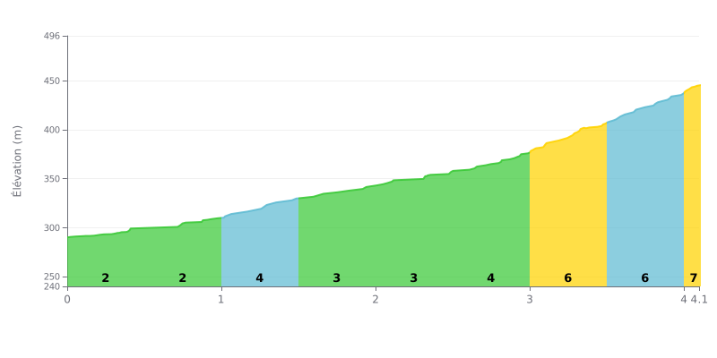
Difficulty breakdown: This 4th category climb is fairly short (4.1 km) and moderate (3.7% average). The challenge lies in how it builds: the first half is very gentle (gradients of 2% to 4%), while the second half gets much harder, with 6% on the final kilometre and even 7% for the last 130 metres.
Tips for pacing the effort:
1. Pacing: Start at a steady tempo and save your legs by making the most of the easy gradients at the beginning. The real difficulty starts after 3 km.
2. Save something for the end: Keep some in the tank for the last kilometre, which is much steeper (6-7%). That's where the climb is decided.
3. Standing up on the pedals: On the final 130 metres at 7%, getting out of the saddle can help you get over the top by keeping your pedal stroke smooth.
4.1 km • 153 m D+
VAM: average climbing speed, based on elevation gain


Join thousands of cycling fans! Plan your rides, record your performance, track your progress and discover the finest climbs.
Live climb profile to pace your effort all the way to the top.

