
Kopřivná is a climb of 7.7 kilometers (category 3). Kopřivná tops out at 640 m above sea level. It is located in okres Šumperk, Střední Morava, Česko. The average gradient is 3.9% with a maximum of 7.2%. The climb has 299 meters of elevation gain.
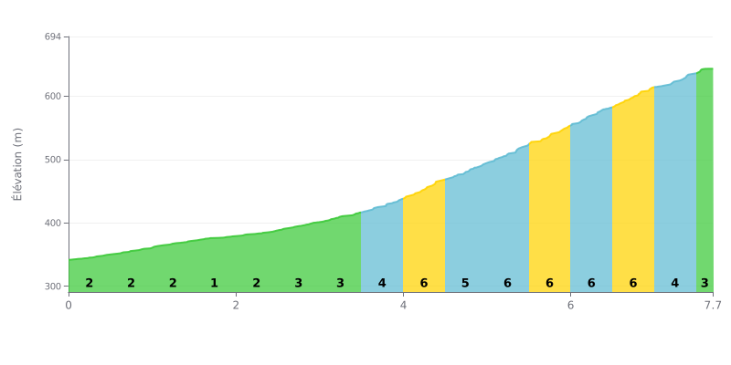
Climb analysis: This 3rd category climb has a progressive difficulty. The first 4 km are very gentle (average gradient of 2%), a warm-up. Things get serious after KM 4.0, with a tough central section of almost 3 km between 4.0 and 7.0 where the gradient stays between 5% and 6%. The final part is a bit easier.
Tips for managing your effort:
1. Pacing: Use the first 4 km, which are fairly flat, to find your rhythm without pushing too hard. Don't go overboard on this easy section.
2. Prepare for the heart of the climb: From KM 4.0 on, get ready mentally and physically for a significant jump in gradient. Shift into an easier gear and adjust your cadence to keep your effort steady.
3. Ease off on the final part: The last 700m at 3-4% give you a chance to recover a little before the summit. Use this section to catch your breath and finish strong.
7.7 km • 299 m D+
VAM: average climbing speed, based on elevation gain


Join thousands of cycling fans! Plan your rides, record your performance, track your progress and discover the finest climbs.
Live climb profile to pace your effort all the way to the top.

