BikeCompanion
Get the app

Wadi al Qilt from מועצה אזורית מגילות ים המלח: what you need to know

Everything about cycling up Wadi al Qilt from מועצה אזורית מגילות ים המלח

Wadi al Qilt is a climb of 13.0 kilometers (category 2). Wadi al Qilt tops out at 160 m above sea level. It is located in מועצה אזורית מגילות ים המלח, יהודה ושומרון, Palestinian Territory. The average gradient is 1.4% with a maximum of 13.3%. The climb has 187 meters of elevation gain.
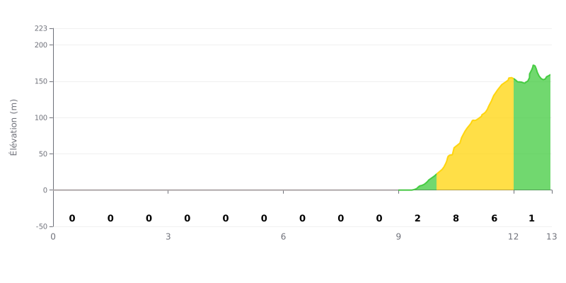
Elevation profile

Elevation profile

Climb statistics

category 2
Difficulty score: 212 (Hard)
Altitude
160 m
Distance
13.0 km
Avg. gradient
1.4 %
Max gradient
13.3 %
Elevation gain
187 m
Steepest section: 13.3% (km 10.5)
Tips

Climb difficulty analysis: This climb has an atypical profile, with 9 km of completely flat road (0%), followed by 3 km of significant gradients (2-7%) that account for most of the elevation gain. The difficulty lies in this abrupt change of rhythm rather than in the overall average gradient of 1.4%, which is very low.

Effort management tips:

  • Ride in a group on the flat to save your energy over the first 9 kilometers.
  • Anticipate the change in gradient at KM 9 and ease into it progressively to avoid a sudden spike in effort.
  • Manage your pace over KM 10-11 (7%), the steepest section, by staying within your target effort zone.

Estimated times

13.0 km • 187 m D+

Leisure 40min
19.5 km/h 350 m/h
Regular 25min
31.1 km/h 550 m/h
Trained 15min
51.9 km/h 800 m/h
Climber 10min
77.8 km/h 1100 m/h
Pro 10min
77.8 km/h 1600 m/h

VAM: average climbing speed, based on elevation gain

Get the app

BikeCompanion App Screenshot BikeCompanion App Screenshot

Join thousands of cycling fans! Plan your rides, record your performance, track your progress and discover the finest climbs.
Live climb profile to pace your effort all the way to the top.


Other sides

Other climbs to Wadi al Qilt