
Tsin Pass is a climb of 3.7 kilometers (category 1). Tsin Pass tops out at 420 m above sea level. It is located in מועצה אזורית הערבה התיכונה, מחוז הדרום, ישראל. The average gradient is 8.7% with a maximum of 19.2%. The climb has 322 meters of elevation gain.
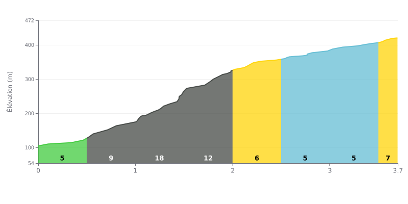
Difficulty breakdown: This category 1 climb has one major difficulty, concentrated in a very short but extremely steep section. The kilometer between 1.0 and 2.0 is the decisive one, with a 19% gradient over 500 meters, followed immediately by 11% over another 500 meters. That's an abrupt 154 meters of elevation gain in just 1 km. The rest of the climb is more moderate, but this central stretch makes it a demanding challenge.
How to manage your effort:
1. Pacing before the steep section: The first 500 meters at 5% give you time to settle into a rhythm without going too hard. Use this section to find your cadence and reach the KM 1.0 mark with something left in the tank.
2. Surviving the decisive kilometer (1.0 - 2.0 km): Get ready to shift down before the 19% begins. The goal is to keep a sustainable cadence, even if you have to back off the power a bit, and get through this "wall" without blowing up.
3. Making the most of the "breather" at the end: After KM 2.0, the gradients ease off considerably, ranging from 4% to 7%. If you've managed your effort well through the central section, you can push on over this last third and finish strong.
For the riders who have climbed it, the ascent of Naqb Gharib from Nahal Tsin is an extremely demanding effort, but one that leaves a lasting memory. Riders' accounts agree on one point: the effort, especially on the final stretch, is intense and brutal.
The payoff, however, matches the challenge. What comes through in the reports is the view of a breathtaking landscape, of almost perfect beauty. The Ramon Crater area is described as majestic, with viewpoints that more than justify the difficulty of the climb.
The experience isn't limited to the bike. Riders mention a place where hikers and off-road vehicles mix, suggesting the area is valued for the variety of activities it offers. The route itself, which follows part of the Israel National Trail, seems to offer an authentic immersion in this one-of-a-kind setting.
The overall feeling that emerges is that this climb is a goal worth chasing. Despite the difficulty reported, the dominant impression is of a rewarding adventure, where the sense of accomplishment is amplified by the discovery of jaw-dropping scenery.
3.7 km • 322 m D+
VAM: average climbing speed, based on elevation gain


Join thousands of cycling fans! Plan your rides, record your performance, track your progress and discover the finest climbs.
Live climb profile to pace your effort all the way to the top.

