
Scorpions’ Ascent is a climb of 2.1 kilometers (category 1). Scorpions’ Ascent tops out at 307 m above sea level. It is located in מועצה אזורית תמר, מחוז הדרום, ישראל. The average gradient is 10.8% with a maximum of 13.1%. The climb has 228 meters of elevation gain.
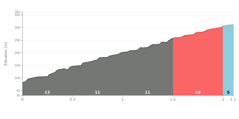
Difficulty breakdown: This short (2.1 km) but punchy climb averages a brutal 11%, typical of a Cat 1. The real problem is the opening: two back-to-back sections at 12% in the first kilometre, accounting for almost half of the total elevation gain (120m out of 228m). The gradient eases gradually but stays steep (10-11%) right up to the last 100 m, which is more manageable at 5%.
Pacing advice:
1. Start controlled: Don't blow up in the opening metres. Save something in the tank for the first 1.5 km, where most of the difficulty is concentrated.
2. Steady rhythm: Hold a constant effort on the 10-12% sections. Avoid surges, as the gradient gives you no real respite until the last 200 m.
3. Final kick: Use the last 100 m at 5% to accelerate and recover a bit before a possible sprint.
2.1 km • 228 m D+
VAM: average climbing speed, based on elevation gain


Join thousands of cycling fans! Plan your rides, record your performance, track your progress and discover the finest climbs.
Live climb profile to pace your effort all the way to the top.

