
Ir Ovot pass is a climb of 10.1 kilometers (category 4). Ir Ovot pass tops out at 70 m above sea level. It is located in מועצה אזורית הערבה התיכונה, מחוז הדרום, ישראל. The average gradient is 0.8% with a maximum of 4.3%. The climb has 86 meters of elevation gain.
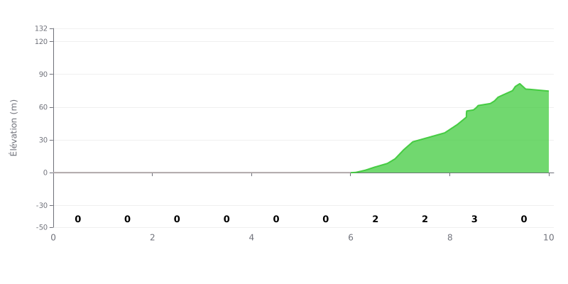
Difficulty breakdown: This category 4 climb is very mild. The difficulty is concentrated over just 3 km (between the 6th and 9th km), with maximum gradients of 2-3%. The first 7 km are completely flat, which makes it an ideal climb for beginners or for getting the legs turning again after a long false flat.
Pacing advice:
1. Steady tempo at the start of the climb: Use the first 6 km at 0% to ride at a strong tempo without redlining, so you hit the steep section with some momentum.
2. Progressive effort on the slopes: Lift your power slightly over km 6 to 9, but without big surges, since gradients of 2-3% are easy to manage.
3. Active recovery on the last km: The final km at 0% gives you a chance to ease off and recover before the summit, if there is one.
For cyclists chasing pure adventure, Ma'ale Ha'aqrabim is a legendary, demanding climb. Riders' reports describe a desert panorama that takes your breath away, with stunning views over the Nahal Tsin and the mountains, a place of total silence and a total sense of being far from everything.
This one is clearly reserved for very experienced, well-equipped riders. The road has been officially closed to traffic for several years according to many witnesses, and it is no longer maintained. It's described as badly broken up, with numerous potholes and collapsed sections, which makes progress technically tough and potentially dangerous, especially with drop-offs at the side.
Despite these challenges, those who have ridden it talk about an epic, unforgettable climb, comparable to the Alpine cols for its winding line. The atmosphere is unique, steeped in history (some even bring up the Biblical traditions) and in the raw beauty of the desert. It's an authentic experience, far off the beaten track, that rewards the effort with "crazy" scenery and a deep sense of accomplishment.
Riders stress the need for careful preparation: check recent access (the road is sometimes blocked by earth barriers), find out about current conditions, and take the route with extreme caution. There is no water source along the route, which adds to the difficulty. For them, it's a gem to discover before it perhaps becomes completely inaccessible.
10.1 km • 86 m D+
VAM: average climbing speed, based on elevation gain


Join thousands of cycling fans! Plan your rides, record your performance, track your progress and discover the finest climbs.
Live climb profile to pace your effort all the way to the top.

