
Nathula is a climb of 28.1 kilometers (hors catégorie). Nathula tops out at 4,278 m above sea level. It is located in 切玛村 བྱེ་མ, 西藏自治区 བོད་རང་སྐྱོང་ལྗོངས།, 中国. The average gradient is 14.4% with a maximum of 24.2%. The climb has 4055 meters of elevation gain.
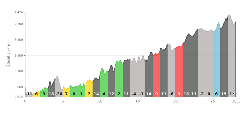
Analysis of the difficulty: This climb is extremely demanding, not only because of its total elevation gain of 4055m over 28.1km, but above all because of its very high average gradient of 14.4%. The real challenge lies in how uneven the profile is: many kilometres sit above 15% (KM3, KM9, KM21, KM26), broken up by flat or slightly downhill stretches that wreck your rhythm.
How to manage the effort:
1. Pacing: Hold a steady power output, especially on the steepest ramps (19%, 21%). Don't surge out of the flat sections, or you'll burn your legs too early.
2. Fueling strategy: With the effort lasting this long, plan your feeding ahead of time. Use the flat or downhill sections (KM4, KM14, KM19) to eat and drink without losing time.
3. Mental preparation: Break the climb into chunks and focus on the hardest parts one at a time, like the final kilometre at 21%.
28.1 km • 4055 m D+
VAM: average climbing speed, based on elevation gain


Join thousands of cycling fans! Plan your rides, record your performance, track your progress and discover the finest climbs.
Live climb profile to pace your effort all the way to the top.


Other climbs to Nathula
Within 20 km