
Merug La is a climb of 31.8 kilometers (hors catégorie). Merug La tops out at 4,467 m above sea level. It is located in n/a, 西藏自治区 བོད་རང་སྐྱོང་ལྗོངས།, 中国. The average gradient is 7.2% with a maximum of 13.8%. The climb has 2303 meters of elevation gain.
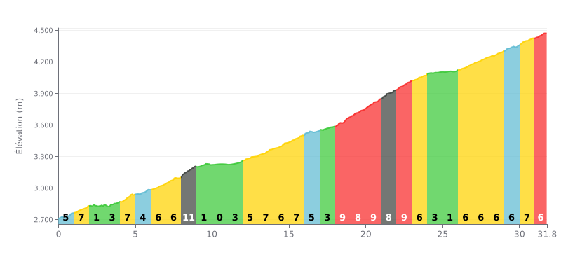
Difficulty analysis: With 2303 m of elevation gain over 31.8 km, this hors catégorie climb is a demanding endurance test. The average gradient of 7.2% is notable, but the real difficulty lies in the irregular profile: long sections at 9% (KM 18-23) alternate with flat or low-gradient stretches (KM 2-3, KM 10-11), which disrupts your rhythm.
Pacing advice:
1. Hold a steady rhythm by targeting a constant power or heart rate, especially in the first kilometres where the gradient is gentler, so you don't blow up early.
2. Prepare for the key sections: KM 18 to 23 (9% over 5 km) is where the climb really bites. Ease off slightly before this section and use the less steep stretch (KM 24-26) to recover.
3. Manage your hydration and feeding on the low-gradient sections (KM 10-11, KM 24-26) where the effort is lighter, so you don't have to interrupt your rhythm on the steep ramps.
31.8 km • 2303 m D+
VAM: average climbing speed, based on elevation gain


Join thousands of cycling fans! Plan your rides, record your performance, track your progress and discover the finest climbs.
Live climb profile to pace your effort all the way to the top.


Within 20 km