
Jelep La is a climb of 85.2 kilometers (hors catégorie). Jelep La tops out at 4,293 m above sea level. It is located in n/a, Sikkim, India. The average gradient is 8.9% with a maximum of 13.7%. The climb has 7597 meters of elevation gain.
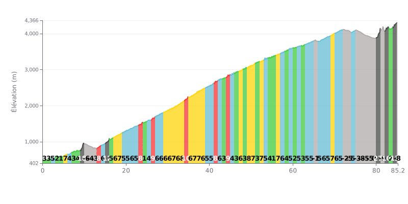
Climb difficulty analysis: This climb is extremely demanding because of its total elevation gain of 7597 m over 85.2 km, for an average gradient of 9%. The difficulty lies in its length and the presence of very steep sections, notably a kilometre at 25% (KM 80-81) and several stretches over 10% (KM 9-10 at 18%, KM 15-16 at 12%, KM 84-85 at 13%). The negative sections (KM 10-13, 72-79) offer brief respites but disrupt your rhythm.
How to manage the effort:
1. Pacing: Hold your power strictly, especially in the first kilometres (easier gradients), so you don't blow up before the critical sections like KM 9-10 (18%).
2. Anticipating gradient changes: Study the profile to modulate your effort: ease off on the descents (e.g. KM 76-77 at -8%) to recover before the steep ramps.
3. Mental approach: Break the climb into blocks (e.g. before/after the big descents) so the total distance doesn't overwhelm you.
For cyclists who have climbed it, Jelep La is much more than just a pass; it's a route steeped in history. Riders speak of its role as a former trade route between India and Tibet, a place where you can feel the weight of the past, especially now that the northern crossing is closed. That historical dimension adds a unique depth to the climb.
Riders' experience is defined by breathtaking scenery and a calm, cool atmosphere. Many describe it as one of the most beautiful spots in India, a high Himalayan pass linking Sikkim to the Chumbi Valley in Tibet. However, some have noted that the site could be cleaner, an aspect that sometimes tempers the experience.
The climb to this strategic tri-junction between India, Bhutan and China is filled with strong national pride among many riders. Reports are full of messages like "Jai Hind" and Indian flags, reflecting a palpable sense of patriotism and vigilance in this sensitive border region.
85.2 km • 7597 m D+
VAM: average climbing speed, based on elevation gain


Join thousands of cycling fans! Plan your rides, record your performance, track your progress and discover the finest climbs.
Live climb profile to pace your effort all the way to the top.


Within 20 km