
Ha Pina is a climb of 8.5 kilometers (category 1). Ha Pina tops out at 458 m above sea level. It is located in Zalafa, מחוז חיפה, ישראל. The average gradient is 4.3% with a maximum of 15.6%. The climb has 370 meters of elevation gain.
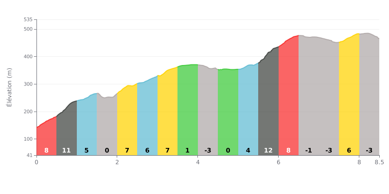
Difficulty breakdown: At 8.5 km, with 370 m of elevation gain and an average gradient of 4.3%, this Cat 1 climb is tough but not extreme. The real challenge is the opening, with 8% between 0.0 and 0.5 km and then 11% between 0.5 and 1.0 km, plus the steepest ramp between 5.5 and 6.0 km at 12%. The flat and downhill sections (1.5-2.0 km, 4.0-4.5 km, 4.5-5.0 km) give you some respite, while the finish is a descent between 8.0 and 8.5 km.
Tips for pacing the climb:
1. Don't go out too hard. The first two kilometres, at 8% and then 11%, will tempt you to start at a pace that's too high, so save some legs for what's coming.
2. Use the flats and descents to recover. Between 1.5 and 2.0 km, and again between 4.0 and 5.0 km, spin a steady cadence to recover before the steep sections.
3. Hold your cadence on the 12% section. Between 5.5 and 6.0 km, drop into a light enough gear, stay seated if you can, and keep a smooth cadence rather than mashing the pedals.
8.5 km • 370 m D+
VAM: average climbing speed, based on elevation gain


Join thousands of cycling fans! Plan your rides, record your performance, track your progress and discover the finest climbs.
Live climb profile to pace your effort all the way to the top.


Other climbs to Ha Pina