
Ha Pina is a climb of 7.6 kilometers (category 1). Ha Pina tops out at 458 m above sea level. It is located in As Sa'aida, יהודה ושומרון, Palestinian Territory. The average gradient is 4.3% with a maximum of 12.2%. The climb has 328 meters of elevation gain.
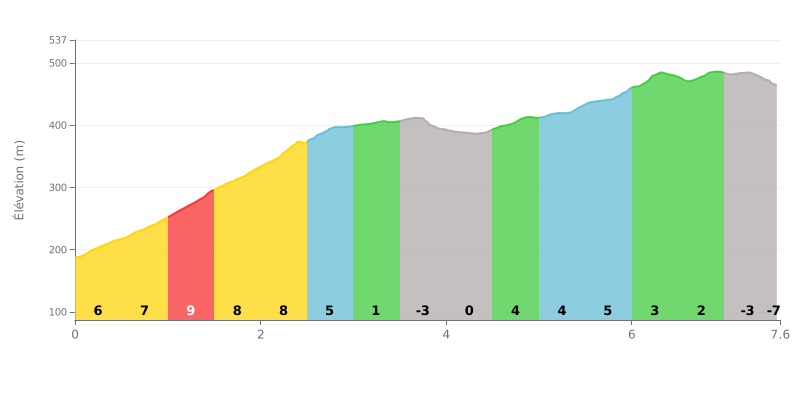
Difficulty breakdown: Ha Pina is a tough climb: 7.6 km with 328 m of elevation gain, at an average gradient of 4.3%. The hard part is the first half. The sections KM 0.0-0.5 through KM 2.0-2.5 sit between 6% and 9%, with the steepest point at 9% between KM 1.0-1.5. After a rolling stretch between KM 3.0-3.5 and KM 4.0-4.5, the road kicks back up to 4% and 5% between KM 4.5-5.0 and KM 5.5-6.0, which makes the finish very selective.
Pacing tips:
1. Don't go out too hard. In the opening kilometres at 6% and 7%, pace yourself and save something for the 9% ramp between KM 1.0-1.5.
2. Make the most of the flat bit. Between KM 3.0-3.5 (2%) and KM 4.0-4.5 (0%), recover by spinning an easy gear at a steady rhythm, without fully backing off.
3. Manage the finish. From KM 5.5-6.0 at 5%, then on the KM 6.5-7.0 section at 1%, hold some power in reserve so you don't lose time on the gradient.
7.6 km • 328 m D+
VAM: average climbing speed, based on elevation gain


Join thousands of cycling fans! Plan your rides, record your performance, track your progress and discover the finest climbs.
Live climb profile to pace your effort all the way to the top.


Other climbs to Ha Pina