
Ha Pina is a climb of 7.3 kilometers (category 1). Ha Pina tops out at 458 m above sea level. It is located in Tayba, n/a, Palestinian Territory. The average gradient is 5.2% with a maximum of 13.4%. The climb has 378 meters of elevation gain.
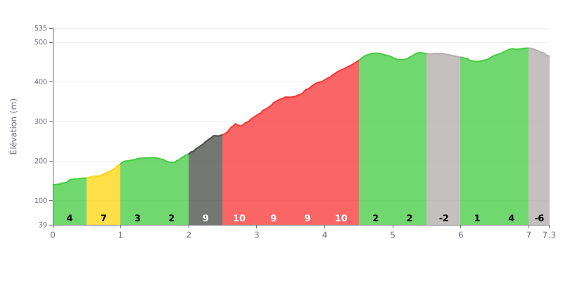
Difficulty analysis: This 7.3 km climb, rated Category 1, averages 5.2% for 378 m of elevation gain. The difficulty is concentrated between km 2.0 and km 4.5, where the gradient stays between 9% and 10% over 2.5 km with no real respite. The opening, with 7% from km 0.5 to km 1.0, sets the tone, while the section from km 4.5 to km 6.5 offers a breather before the final effort.
Tips for the effort:
1. Pace your start. Avoid going too hard on the 7% section from km 0.5 to km 1.0 so you have something left for the central block.
2. Settle into a rhythm on the km 2.0 to km 4.5 block. Stay seated, pick a gear that lets you hold a steady cadence, and avoid unnecessary surges on these 9-10% ramps.
3. Recover on the rolling sections. Make the most of the false flat from km 4.5 to km 5.0 at 1% and the slightly downhill stretch from km 5.5 to km 6.0 to catch your breath and gradually build your effort back up.
7.3 km • 378 m D+
VAM: average climbing speed, based on elevation gain


Join thousands of cycling fans! Plan your rides, record your performance, track your progress and discover the finest climbs.
Live climb profile to pace your effort all the way to the top.


Other climbs to Ha Pina