
Tai Po Kau is a climb of 3.5 kilometers (category 1). Tai Po Kau tops out at 455 m above sea level. It is located in 荃灣區 Tsuen Wan District, 香港 Hong Kong, 中国. The average gradient is 8.3% with a maximum of 13.6%. The climb has 292 meters of elevation gain.
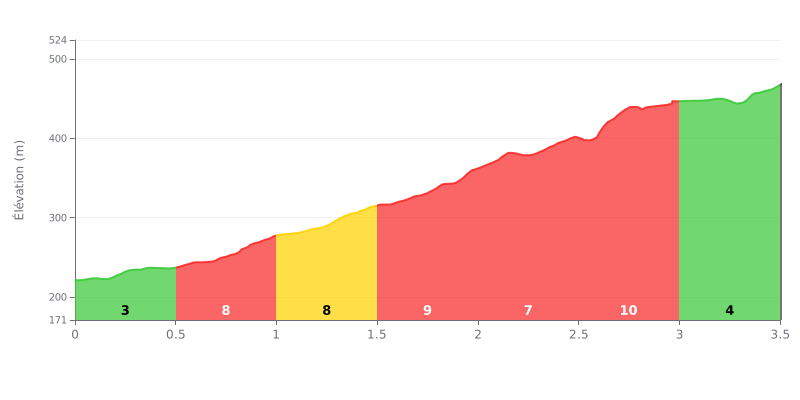
Difficulty breakdown: This Category 1 climb is a sustained grind, with an average gradient of 8.3% over a fairly short distance. The difficulty is ramped up by two steep sections at 9% between 1.5-2.0 km and 2.5-3.0 km, which are the key crux points. The final half-kilometer at 5% gives you a welcome breather.
How to manage your effort:
1. Pace yourself: Start easy over the first 500m at 3% so you don't burn all your matches before the 8-9% sections.
2. Save something for the two spikes: Keep some in the tank for the two 9% sections (1.5-2.0 km and 2.5-3.0 km). Ease off the pace slightly as you approach these segments.
3. Use the easier finish: The last 500m at 5% is where to go again if your legs allow, so you can finish strong.
3.5 km • 292 m D+
VAM: average climbing speed, based on elevation gain


Join thousands of cycling fans! Plan your rides, record your performance, track your progress and discover the finest climbs.
Live climb profile to pace your effort all the way to the top.

