
Tai Po Kau is a climb of 4.7 kilometers (category 1). Tai Po Kau tops out at 455 m above sea level. It is located in 大埔區 Tai Po District, 香港 Hong Kong, 中国. The average gradient is 9.4% with a maximum of 22.3%. The climb has 439 meters of elevation gain.
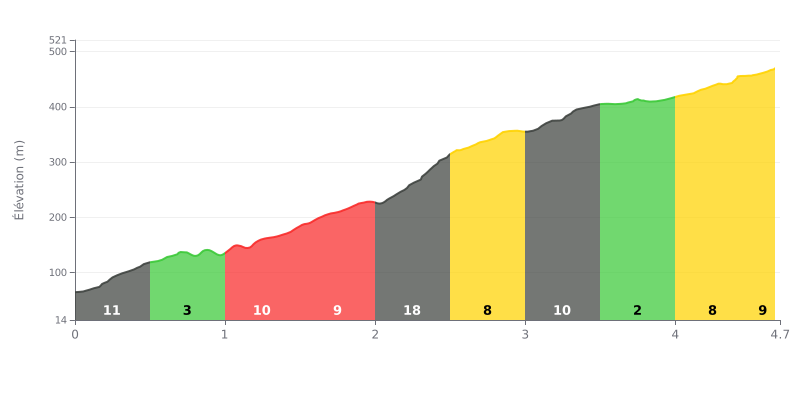
Analysis of the difficulty:
This Category 1 climb is genuinely tough because of its uneven profile. The average gradient of 9% is already demanding, but the kilometre between 2.0 and 2.5, at 18%, is the crux of the climb and will decide how hard the whole ascent feels. The 10-11% sections early on and mid-climb also require good pacing.
Tips for managing your effort:
1. Pace yourself before the wall: Ride the first couple of kilometres (0-2 km) within yourself to save your legs for the 18% maximum gradient.
2. Shift down for the key section: Anticipate the change in gradient around the 2.0 km mark and shift onto an easier gear early so you can hold your cadence through the 18% stretch.
3. Use the recovery section: The gentler 3% section between 3.5 and 4.0 km is your chance to recover a little before the final steady part at 8-9%.
4.7 km • 439 m D+
VAM: average climbing speed, based on elevation gain


Join thousands of cycling fans! Plan your rides, record your performance, track your progress and discover the finest climbs.
Live climb profile to pace your effort all the way to the top.

