
Sha Tin Pass is a climb of 3.8 kilometers (hors catégorie). The climb finishes at 300 m above sea level. It is located in Hong Kong, n/a, 中国. The average gradient is 9.7% with a maximum of 15.9%. The climb has 368 meters of elevation gain.
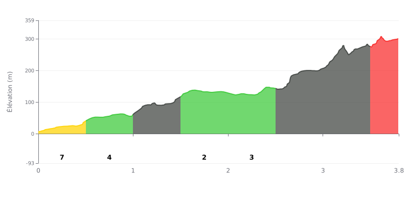
Difficulty breakdown: With 3.8 km at an average gradient of 9.7% and 368 m of elevation gain, this climb is rated HC and demands a sustained effort from start to finish. The hardest section is between km 2.5 and km 3.5, with gradients of 13% then 14%, which form the heart of the climb. The stretch from km 1.0 to 1.5, at 11%, is the first real test, before a breather between km 1.5 and 2.5 where the gradient drops to 2% then 3%.
Tips for pacing the effort:
1. Ease into it: the km 0.0 to 1.0 section (7% then 5%) should be ridden at a steady, moderate pace to save something in the tank for what's coming.
2. Recover on the rolling section: between km 1.5 and km 2.5 (2% then 3%), use the flatter ground to get your breathing back under control and build some momentum with a fairly long gear.
3. Save something for the finale: before km 2.5, shift into a gear you can manage, stay smooth and seated to hold the 13% and 14% through to km 3.5, then grind out the final 9% section.
Those who have climbed the Sha Tin Pass first mention an easy-to-reach viewpoint, with Kowloon below and, on a clear day, Hong Kong in the distance. The downside is the amount of litter all around, which spoils the scenery a bit.
One rider describes a small stream, the sound of birds and insects, and trees dense enough to give real shade. For him, it's a good spot for hiking.
Another finds the area less busy than other popular trails in the region. The vegetation is very different, and he says he enjoyed his hikes here.
Keep in mind that these accounts are mostly about hiking trails. None of them says anything about the road, the gradient or the traffic, so nothing can be taken from them for the climb by bike.
3.8 km • 368 m D+
VAM: average climbing speed, based on elevation gain


Join thousands of cycling fans! Plan your rides, record your performance, track your progress and discover the finest climbs.
Live climb profile to pace your effort all the way to the top.


Within 20 km