
Przełęcz Sokołowska is a climb of 5.5 kilometers (category 3). The climb finishes at 561 m above sea level. It is located in Stary Wielisław, województwo dolnośląskie, Polska. The average gradient is 3.5% with a maximum of 10.7%. The climb has 192 meters of elevation gain.
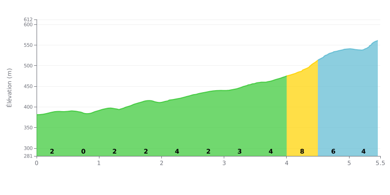
Difficulty breakdown: At 5.5 km for 192 m of elevation gain and an average gradient of 3.5%, the Przełęcz Sokołowska comes in as a 3rd category climb, but it's not a major test. The opening, from km 0.0 to km 2.0, is rolling at 1 to 2%, then the grade ramps up to 4% between km 2.0 and 2.5 and again between km 3.0 and 4.0. The real crux is at km 4.0-4.5 with a 8% kick, followed by two kilometres at 5% to the summit.
Tips for managing your effort:
1. Settle in early. From km 0.0 to 2.0, hold a steady rhythm so your legs have something left for the 4% sections.
2. Prepare for the 8% ramp. At km 4.0-4.5, shift into an easier gear, keep your cadence smooth and avoid jerky pedal strokes.
3. Don't blow up on the way up. Over km 4.5 to 5.5 at 5%, keep the power on but under control all the way to the top.
People who have been to Przełęcz Sokołowska mostly talk about the scenery. On a clear day the views are stunning, and several testimonies say so.
For those arriving by car, parking is free. The trail up to Kamienna Góra starts right near the pass.
Another testimony is mostly about a stroll: after a good meal, you can walk a bit on the trail, which is easy, light and pleasant, with benches along the way.
The testimonies received say nothing about the climb itself on the bike: neither the gradient, nor the condition of the road, nor the traffic. No negative point is mentioned.
5.5 km • 192 m D+
VAM: average climbing speed, based on elevation gain


Join thousands of cycling fans! Plan your rides, record your performance, track your progress and discover the finest climbs.
Live climb profile to pace your effort all the way to the top.


Other climbs to Przełęcz Sokołowska