
Przełęcz pod Uboczem is a climb of 4.2 kilometers (category 3). The climb finishes at 735 m above sea level. It is located in Paszków, województwo dolnośląskie, Polska. The average gradient is 4.3% with a maximum of 8.3%. The climb has 181 meters of elevation gain.
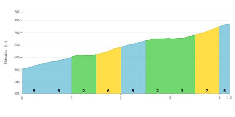
Difficulty breakdown: At 4.2 km for 181 m of elevation gain and an average gradient of 4.3%, the Przełęcz pod Uboczem climb rates as a Cat 3 and is doable for any regular rider. The real challenge is the relentless effort: the road gives you almost no breathing room, with 5% stretches right from the start (KM 0.0-0.5 and KM 0.5-1.0) and steeper sections between KM 1.5-2.0 (6%) and KM 3.5-4.0 (7%). The 2% sections (KM 1.0-1.5 and KM 2.5-3.0) are the only real recovery spots on the climb.
Pacing tips:
1. Start controlled. Don't go out too hard over the first 1,000 metres at 5%. Save something in the tank for the second half of the col.
2. Use the flat bits. Take advantage of the 2% sections at KM 1.0-1.5 and KM 2.5-3.0 to drink, eat something and get your cadence back to a smooth spin.
3. Prep for the finish. Hit KM 3.5-4.0 at 7% in a gear light enough to keep spinning, then hold a steady cadence over the final 200 metres at 5%.
The Przełęcz pod Uboczem (Przełęcz pod Uboczem pass) is a small pass between two gentle ridges in the Bystrzyca Mountains (Góry Bystrzyckie). People who talk about it stress how quiet it is. Not many riders come through, and the spot is surrounded by spruce and mixed forest.
As far as riding goes, there aren't many reports, and they're short. One rider simply says it's great for a ride, on foot or on the bike. Nobody describes the gradient, the road surface or the traffic, so you don't really know what to expect on the climb itself.
On site, the pass is well signposted and has a picnic table with benches. There's no refuge and no big car park, and several people say you can leave your car there and head out on foot into the Bystrzyca Mountains. That keeps the place feeling pretty wild.
No negatives are mentioned: no traffic, no noise, no litter. But the reports are brief, so this picture is limited.
4.2 km • 181 m D+
VAM: average climbing speed, based on elevation gain


Join thousands of cycling fans! Plan your rides, record your performance, track your progress and discover the finest climbs.
Live climb profile to pace your effort all the way to the top.

