
Chui Rax Amolo is a climb of 7.4 kilometers (category 1). Chui Rax Amolo tops out at 2,639 m above sea level. It is located in Novillero, Sololá, Guatemala. The average gradient is 4.2% with a maximum of 15.6%. The climb has 310 meters of elevation gain.
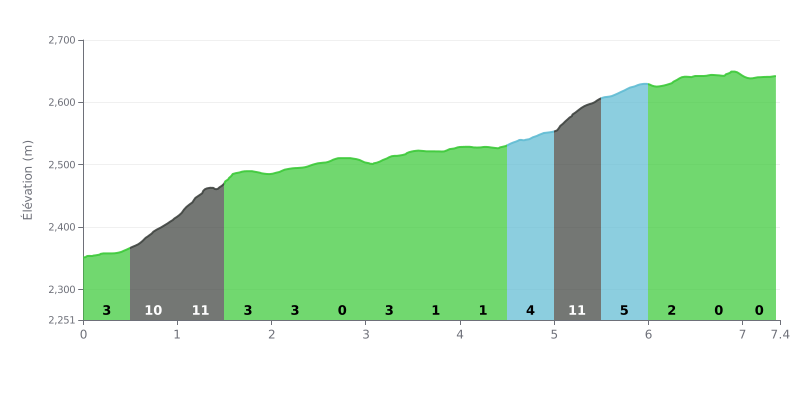
Difficulty breakdown: At 7.4 km for 310 m of elevation gain and an average gradient of 4.2%, this Cat 1 climb stands out mainly for its consistency. The steepest sections are between KM 0.5-1.0 and KM 1.0-1.5 (10 to 11%), then at KM 5.0-5.5 (11%), where the effort really ramps up. The 0% stretches (KM 2.5-3.0 and KM 6.5-7.0) give you a bit of breathing room, while the KM 7.0-7.4 section at 1% shouldn't make you forget that the climb isn't over yet.
Tips for managing your effort:
1. Pace the start. Don't go too hard through KM 0.5-1.0: take the 10% section with a smooth cadence so you have something left for the 11% of KM 1.0-1.5.
2. Recover on the flat bits. Use the 0% sections at KM 2.5-3.0 and KM 6.5-7.0 to drink, eat and get your rhythm back.
3. Adjust your gearing at KM 5.0-5.5. On this 11% ramp, go for a gear light enough to keep a steady cadence, and stay seated if you can to maintain good power transfer.
According to the cyclists who've ridden up, the climb to the Parque Ecológico Chuiraxamolo is an instant immersion in unspoiled nature. Riders describe trails lined with greenery, fresh air and total peace and quiet, far from the noise of the city. It's a "real treasure" for meditating and reconnecting, although some mention that the access road for vehicles is in "pretty bad" shape.
The payoff for the effort gets unanimous praise: the panoramic views over Lake Atitlán and the surrounding volcanoes are described as "spectacular", "impressive" and "exceptional". Riders report that the park has plenty of lookouts to take in this one-of-a-kind scenery, although some point out that on overcast days the view can be limited. The climb itself, on trails described as "rudimentary", can be "a bit tiring" and takes real effort, especially on steep terrain.
Once at the top, the experience goes beyond cycling. Testimonials describe a place that's ideal for relaxing with family or friends, with the option of a picnic ("churrasqueras"), some extra hiking on the trails, or even camping for the more adventurous, though it does get "pretty cold" at night. The place is seen as safe and well maintained, with "very friendly" staff.
For thrill seekers, the park is known for its canopy, billed as the longest or one of the highest in Central America, offering a dizzying view over the lake. Cyclists also stress that access is very affordable, making for a complete and memorable experience that combines athletic effort with a connection to nature.
7.4 km • 310 m D+
VAM: average climbing speed, based on elevation gain


Join thousands of cycling fans! Plan your rides, record your performance, track your progress and discover the finest climbs.
Live climb profile to pace your effort all the way to the top.

